Gangarampur subdivision | |
|---|---|
Subdivision | |
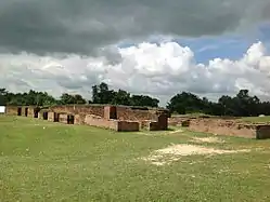
 Historical ruins of Bangarh | |
_in_Dakshin_Dinajpur_(West_Bengal).svg.png.webp) | |
| Coordinates: 25°24′N 88°31′E / 25.40°N 88.52°E | |
| Country | |
| State | West Bengal |
| District | South Dinajpur |
| Headquarter | Buniadpur |
| Area | |
| • Total | 1,047.90 km2 (404.60 sq mi) |
| Population (2011) | |
| • Total | 770,736 |
| • Density | 740/km2 (1,900/sq mi) |
| Languages | |
| • Official | Bengali, English |
| Time zone | UTC+5:30 (IST) |
| ISO 3166 code | ISO 3166-2:IN |
| Vehicle registration | WB |
Gangarampur subdivision is an administrative subdivision of the Dakshin Dinajpur district in the Indian state of West Bengal.
Subdivisions
Dakshin Dinajpur district is divided into two administrative subdivisions:[1]
.svg.png.webp)
| Subdivision | Headquarters | Area km22001 | Population (2011) | Urban Population % (2011) | Rural Population % (2011) |
|---|---|---|---|---|---|
| Balurghat | Balurghat | 1,202.88 | 905,540 | 18.56 | 81.44 |
| Gangarampur | Buniadpur | 1,047.90 | 770,736 | 8.86 | 91.14 |
| Dakshin Dinajpur district | Balurghat | 2,219.00* | 1,676,276 | 14.10 | 85.90 |
.*2011
Administrative units
Gangarampur subdivision has 4 police stations, 4 community development blocks, 4 panchayat samitis, 30 gram panchayats, 750 mouzas, 730 inhabited villages, 2 municipalities and 2 census towns. The municipalities are at Gangarampur and Buniadpur. The census towns are: Gopalpur and Harirampur. The subdivision has its headquarters at Buniadpur.[1]
Police stations
Police stations in Balurghat subdivision have the following features and jurisdiction:[1][2]
| Police station | Area covered (km2) | Border (km) | Population | Municipal town/ city | CD Block |
|---|---|---|---|---|---|
| Gangarampur | n/a | n/a | ? | Gangarampur | Gangarampur |
| Kushmandi | n/a | n/a | ? | - | Kushmandi |
| Bansihari | n/a | - | ? | Buniadpur | Bansihari |
| Harirampur | n/a | - | ? | - | Harirampur |
Blocks
Community development blocks in Balurghat subdivision are:[1][3][4]
.svg.png.webp)
| CD Block | Headquarters | Area km2 | Population (2011) | SC % | ST % | Hindus % | Muslims % | Literacy Rate % | Census Towns |
|---|---|---|---|---|---|---|---|---|---|
| Gangarampur | Gangarampur | 315.52 | 237,628 | 30.41 | 0.13 | 63.66 | 34.44 | 71.45 | 1 |
| Kushmandi | Kushmandi | 310.63 | 198,752 | 44.76 | 7.86 | 60.38 | 38.73 | 65.43 | - |
| Bansihari | Buniadpur | 196.52 | 141,286 | 12.39 | 21.95 | 73.99 | 24.21 | 68.79 | - |
| Harirampur | Harirampur | 214.94 | 136,853 | 21.81 | 16.85 | 49.62 | 47.98 | 64.67 | 1 |
Gram panchayats
The subdivision contains 30 gram panchayats under 4 community development blocks:[5][6]
- Gangarampur block consists of 11 gram panchayats, viz. Ashokegram, Belbari–II, Gangarampur, Sukdevpur, Basuria, Chaloon, Jahangirpur, Uday, Belbari–I, Damdama and 4no.Nandanpur.
- Banshihari block consists of 4 gram panchayats, viz. Ellahabad, Ganguria, Brajaballavpur and Mahabari.
- Harirampur block consists of 6 gram panchayats, viz. Bagichapur, Gokarna, Saiyadpur, Bairhatta, Pundari and Shirshi.
- Kushmandi block consists of 8 gram panchayats, viz. Akcha, Deul, Karanji, Maligaon, Beroil, Kalikamora, Kushmandi and Udaypur.
Education
Dakshin Dinajpur district had a literacy rate of 72.82% (for population of 7 years and above) as per the census of India 2011. Balurghat subdivision had a literacy rate of 75.78%, Gangarampur subdivision 69.24%.[7]
Given in the table below (data in numbers) is a comprehensive picture of the education scenario in Dakshin district for the year 2013-14:[7]
| Subdivision | Primary School |
Middle School |
High School |
Higher Secondary School |
General College, Univ |
Technical / Professional Instt |
Non-formal Education | |||||||
|---|---|---|---|---|---|---|---|---|---|---|---|---|---|---|
| Institution | Student | Institution | Student | Institution | Student | Institution | Student | Institution | Student | Institution | Student | Institution | Student | |
| Balurghat | 671 | 46,548 | 42 | 4,482 | 52 | 74,677 | 55 | 68,352 | 4 | 6,930 | 4 | 385 | 2,304 | 55,876 |
| Gangarampur | 505 | 51,355 | 56 | 5,078 | 33 | 82,967 | 51 | 69,003 | 3 | 7,100 | 1 | 100 | 1,457 | 51,230 |
| Dakshin Dinajpur district | 1,176 | 97,903 | 98 | 9,560 | 85 | 157,644 | 106 | 137,655 | 7 | 14,030 | 5 | 485 | 3,761 | 107,106 |
Note: Primary schools include junior basic schools; middle schools, high schools and higher secondary schools include madrasahs; technical schools include junior technical schools, junior government polytechnics, industrial technical institutes, industrial training centres, nursing training institutes etc.; technical and professional colleges include engineering colleges, medical colleges, para-medical institutes, management colleges, teachers training and nursing training colleges, law colleges, art colleges, music colleges etc. Special and non-formal education centres include sishu siksha kendras, madhyamik siksha kendras, centres of Rabindra mukta vidyalaya, recognised Sanskrit tols, institutions for the blind and other handicapped persons, Anganwadi centres, reformatory schools etc.[7]
The following institutions are in Gangarampur subdivision:
Gangarampur College was established in 1981 at Gangarampur.[8]
Buniadpur Mahavidyalaya was established at Buniadpur in 2007.[9]
Dewan Abdul Gani College was established at Harirampur in 1994.[10][11]
Kushmandi Government College was established at Kushmandi in 2015.[12][13]
Healthcare
The table below (all data in numbers) presents an overview of the medical facilities available and patients treated in the hospitals, health centres and sub-centres in 2014 in Dakshin Dinajpur district.[14]
| Subdivision | Health & Family Welfare Deptt, WB | Other State Govt Deptts |
Local bodies |
Central Govt Deptts / PSUs |
NGO / Private Nursing Homes |
Total | Total Number of Beds |
Total Number of Doctors* |
Indoor Patients |
Outdoor Patients | |||
|---|---|---|---|---|---|---|---|---|---|---|---|---|---|
| Hospitals |
Rural Hospitals |
Block Primary Health Centres |
Primary Health Centres | ||||||||||
| Balurghat | 1 | 4 | 1 | 12 | 1 | 1 | - | 3 | 23 | 822 | 69 | 64,346 | 1,233,046 |
| Gangarampur | 1 | 3 | - | 6 | - | - | - | 6 | 16 | 465 | 43 | 49,043 | 898,363 |
| Dakshin Dinajpur district | 2 | 7 | 1 | 18 | 1 | 1 | - | 9 | 39 | 1,287 | 112 | 113,389 | 2,131,409 |
.* Excluding nursing homes
Medical facilities available in Gangarampur subdivision are as follows:
Hospitals: (Name, location, beds)[15]
Gangarampur subdivisional hospital, Gangarampur, 250 beds
Rural Hospitals: (Name, block, location, beds)[15]
Harirampur Rural Hospital, Harirampur CD Block, Harirampur, 30 beds
Rashidpur Rural Hospital, Bansihari CD Block, Rashidpur, 30 beds
Kushmandi Rural Hospital, Kushmandi CD Block, Kushmandi, Dakshin Dinajpur, 30 beds
Block Primary Health Centre: (Name, location, beds)[15]
Mathurapur (Chalon) BPHC, Gangarampur CD Block, PO Bansagar, 10 beds
Primary Health Centres: (CD Block-wise)(CD Block, PHC location, beds)[15]
Gangarampur CD Block: Sarbamangala (Sarbamangala (Bansuria) PHC) (10)
Harirampur CD Block: Balihara (10)
Bansihari CD Block: Badalpur (10)
Kushmandi CD Block: Sehail (Nanaharpara PHC) (10), Aminpur (10)
Electoral constituencies
Lok Sabha (parliamentary) and Vidhan Sabha (state assembly) constituencies in Gangarampur subdivision were as follows:[16]
| Lok Sabha constituency | Reservation | Vidhan Sabha constituency | Reservation | CD Block and/or Gram panchayats and/or municipal areas |
|---|---|---|---|---|
| Balurghat | None | Gangarampur | SC | Gangarampur municipality, Belbari I, Damdama, Gangarampur and Nandanpur GPs of Gangrampur CD Block, and Ajmatpur, Autina, Gurail, Hazratpur, Ramchandrapur and Rampara Chenchra GPs of Tapan CD Block |
| Kushmandi | SC | Kushmandi CD Block and Belbari II, Jahangirpur and Sukdebpur GPs of Gangarampur | ||
| Harirampur | None | Harirampur CD Bloock and Bansihari CD Block | ||
| Kumarganj | None | Kumarganj CD Block and Ashokegram, Basuria, Chaloon and Uday GPs of Gangarampur CD Block | ||
| Other assembly segments outside the subdivision | ||||
References
- 1 2 3 4 "District Statistical Handbook 2014 Dakshin Dinajpur". Table 2.1 , 2.2, 2.4b. Department of Statistics and Programme Implementation, Government of West Bengal. Retrieved 4 December 2018.
- ↑ "Dakshin Dinajpur District Police". Know your PS. District Police. Archived from the original on 28 November 2017. Retrieved 4 December 2018.
- ↑ "District Census Handbook: Dakshin Dinajpur, Series 20 Part XII A" (PDF). Map of Dakshin Dinajpur with CD Block HQs and Police Stations (on the fourth page). Directorate of Census Operations, West Bengal, 2011. Retrieved 4 December 2018.
- ↑ "BDO Offices under Dakshin Dinajpur District". Department of Mass Education Extension & Library Services, Government of West Bengal. West Bengal Public Library Network. Archived from the original on 2 November 2018. Retrieved 4 December 2018.
- ↑ "Directory of District, Subdivision, Panchayat Samiti/ Block and Gram Panchayats in West Bengal". Dakshin Dinajpur - Revised in March 2008. Panchayats and Rural Development Department, Government of West Bengal. Retrieved 4 December 2018.
- ↑ "List of Districts/C.D.Blocks/ Police Stations with Code No., Number of G.Ps and Number of Mouzas". Census of India, Directorate of Census Operations, West Bengal. Archived from the original on 13 February 2010. Retrieved 4 December 2018.
- 1 2 3 "District Statistical Handbook 2014 Dakshin Dinajpur". Basic data: Table 4.4, 4.5, Clarifications: other related tables. Department of Planning, Statistics and Programme Monitoring, Government of West Bengal. Retrieved 6 December 2018.
- ↑ "Gangarampur College". GC. Retrieved 7 December 2018.
- ↑ "Buniadpur Mahavidyalaya". BM. Retrieved 7 December 2018.
- ↑ "Dewan Abdul Gani College". DAGC. Retrieved 4 December 2018.
- ↑ "Dewan Abdul Gani College". College Admission. Retrieved 4 December 2018.
- ↑ "Government General Degree College, Kushmandi". GGDC. Retrieved 4 December 2018.
- ↑ "Kushmandi Government College". examfinder. Retrieved 4 December 2018.
- ↑ "District Statistical Handbook 2014 Dakshin Dinajjpur". Table 3.1, 3.3. Department of Planning, Statistics and Programme Monitoring, Government of West Bengal. Retrieved 6 December 2018.
- 1 2 3 4 "Health & Family Welfare Department". Health Statistics. Government of West Bengal. Retrieved 7 December 2018.
- ↑ "Delimitation Commission Order No. 18, 15 February 2006" (PDF). West Bengal. Election Commission of India. Retrieved 7 December 2018.
