Enrekang Regency
Kabupaten Enrekang | |
|---|---|
 Coat of arms | |
| Motto: Massenrempulu | |
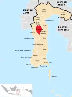 Location within South Sulawesi | |
| Country | Indonesia |
| Province | South Sulawesi |
| Capital | Enrekang |
| Area | |
| • Total | 1,821.53 km2 (703.30 sq mi) |
| Population (mid 2022 estimate)[1] | |
| • Total | 228,554 |
| • Density | 130/km2 (320/sq mi) |
| Time zone | UTC+8 (WITA) |
Enrekang Regency is an inland regency of South Sulawesi Province of Indonesia. It covers an area of 1,821.53 km2 and had a population of 190,175 at the 2010 census[2] and 225,172 at the 2020 census;[3] the official estimate as at mid 2022 was 228,554 (comprising 116,291 males and 112,263 females).[1] The principal town lies at Enrekang.
Administrative districts
Enrekang Regency comprises twelve administrative districts (Kecamatan), tabulated below with their areas and their populations at the 2010 census[2] and the 2020 census,[3] together with the official estimates as at mid 2022.[1] The table also includes the locations of the district administrative centres, the number of administrative villages in each district (totaling 112 rural desa and 17 urban kelurahan), and its post code.
| Kode Wilayah | Name of District (kecamatan) | Area in km2 | Pop'n census 2010 | Pop'n census 2020 | Pop'n Estimate mid 2022 | Admin centre | No. of desa | No. of kelurahan | Post code |
|---|---|---|---|---|---|---|---|---|---|
| 73.16.01 | Maiwa | 400.74 | 23,119 | 27,880 | 28,182 | Bangkala | 21 | 1 | 91760 |
| 73.16.06 | Bungin | 241.53 | 4,345 | 5,508 | 5,600 | Bungin | 6 | - | 91761 |
| 73.16.02 | Enrekang | 296.91 | 30,568 | 37,080 | 37,123 | Juppandang | 12 | 6 | 91711 & 91712 |
| 73.16.07 | Cendana | 92.90 | 8,695 | 9,935 | 10,044 | Cendana | 7 | - | 91711 |
| 73.16.03 | Baraka | 162.30 | 21,201 | 23,539 | 23,953 | Baraka | 12 | 3 | 91753 |
| 73.16.10 | Buntu Batu | 129.15 | 12,779 | 15,248 | 15,699 | Pasui | 8 | - | 91750 |
| 73.16.04 | Anggeraja | 127.87 | 23,825 | 28,468 | 28,811 | Lakawan | 12 | 3 | 91752 |
| 73.16.09 | Malua | 41.17 | 7,641 | 9,154 | 9,293 | Malua | 7 | 1 | 91751 |
| 73.16.05 | Alla | 35.34 | 20,657 | 24,116 | 24,687 | Kambiolangi | 5 | 3 | 91754 |
| 73.16.08 | Curio | 181.97 | 14,841 | 17,816 | 18,185 | Curio | 11 | - | 91756 |
| 73.16.11 | Masalle | 69.76 | 12,298 | 14,612 | 14,915 | Masalle | 6 | - | 91757 |
| 73.16.12 | Baroko | 41.90 | 10,279 | 11,816 | 12,062 | Baroko | 5 | - | 91755 |
| Totals | 1,821.53 | 190,175 | 225,172 | 228,554 | Enrekang | 112 | 17 |
Climate
Enrekang has a tropical rainforest climate (Af) with heavy rainfall year-round. The following climate data is for the town of Enrekang.
| Climate data for Enrekang | |||||||||||||
|---|---|---|---|---|---|---|---|---|---|---|---|---|---|
| Month | Jan | Feb | Mar | Apr | May | Jun | Jul | Aug | Sep | Oct | Nov | Dec | Year |
| Mean daily maximum °C (°F) | 29.9 (85.8) |
30.0 (86.0) |
30.4 (86.7) |
30.7 (87.3) |
30.8 (87.4) |
30.2 (86.4) |
30.0 (86.0) |
30.9 (87.6) |
31.3 (88.3) |
31.9 (89.4) |
31.2 (88.2) |
30.3 (86.5) |
30.6 (87.1) |
| Daily mean °C (°F) | 26.4 (79.5) |
26.5 (79.7) |
26.7 (80.1) |
26.8 (80.2) |
27.0 (80.6) |
26.3 (79.3) |
25.7 (78.3) |
26.2 (79.2) |
26.5 (79.7) |
27.2 (81.0) |
27.1 (80.8) |
26.6 (79.9) |
26.6 (79.9) |
| Mean daily minimum °C (°F) | 22.9 (73.2) |
23.1 (73.6) |
23.0 (73.4) |
23.0 (73.4) |
23.2 (73.8) |
22.4 (72.3) |
21.4 (70.5) |
21.5 (70.7) |
21.7 (71.1) |
22.5 (72.5) |
23.0 (73.4) |
23.0 (73.4) |
22.6 (72.6) |
| Average rainfall mm (inches) | 316 (12.4) |
171 (6.7) |
184 (7.2) |
295 (11.6) |
235 (9.3) |
175 (6.9) |
140 (5.5) |
138 (5.4) |
195 (7.7) |
157 (6.2) |
168 (6.6) |
236 (9.3) |
2,410 (94.8) |
| Source: Climate-Data.org[4] | |||||||||||||
References
Regencies and cities of South Sulawesi | ||
|---|---|---|
Capital: Makassar | ||
| Regencies |  | |
| Cities | ||
3°33′52″S 119°46′29″E / 3.56444°S 119.77472°E