Dobro Polje | |
|---|---|
 | |
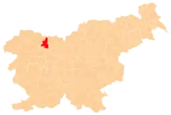
 Dobro Polje Location in Slovenia | |
| Coordinates: 46°19′23.09″N 14°13′24.27″E / 46.3230806°N 14.2234083°E | |
| Country | |
| Traditional region | Upper Carniola |
| Statistical region | Upper Carniola |
| Municipality | Radovljica |
| Elevation | 463.1 m (1,519.4 ft) |
| Population (2002) | |
| • Total | 119 |
| [1] | |
Dobro Polje (pronounced [ˈdɔːbɾɔ ˈpoːljɛ], German: Gutenfeld[2]) is a settlement on the left bank of the Sava River in the Municipality of Radovljica in the Upper Carniola region of Slovenia.
Geography

Malo Dobro Polje
Dobro Polje is divided into the hamlet of Malo Dobro Polje (literally, 'little Dobro Polje'; German: Kleingutenfeld) to the southeast and the main settlement of Veliko Dobro Polje (literally, 'big Dobro Polje'; German: Großgutenfeld) to the northwest.[2][3][4][5] It is located in the lower part of the Brezje Basin. The soil is thin and sandy, limiting agriculture. Peračica Creek, a tributary of the Sava River, flows through a deep bed east of the village.[3]
References
- ↑ Statistical Office of the Republic of Slovenia
- 1 2 Leksikon občin kraljestev in dežel zastopanih v državnem zboru, vol. 6: Kranjsko. Vienna: C. Kr. Dvorna in Državna Tiskarna. 1906. p. 148.
- 1 2 Savnik, Roman (1968). Krajevni leksikon Slovenije, vol. 1. Ljubljana: Državna založba Slovenije. p. 280.
- ↑ Zupan, Ciril (May 19, 2015). "Vas Dobro Polje". Gorenjski glas. Retrieved August 11, 2019.
- ↑ Lavrenčak, Goran (2018). Dobro polje – od prve omembe do leta 1900 (PDF). Retrieved August 11, 2019.
External links
 Media related to Dobro Polje at Wikimedia Commons
- Dobro Polje on Geopedia
| Settlements | Administrative seat: Radovljica
|  |
|---|---|---|
| Landmarks |
| |
| Notable people |
| |
This article is issued from Wikipedia. The text is licensed under Creative Commons - Attribution - Sharealike. Additional terms may apply for the media files.