Denwood, Arkansas | |
|---|---|
 Denwood  Denwood | |
| Coordinates: 35°29′17″N 90°15′03″W / 35.48806°N 90.25083°W | |
| Country | United States |
| State | Arkansas |
| County | Mississippi |
| Elevation | 226 ft (69 m) |
| Time zone | UTC-6 (Central (CST)) |
| • Summer (DST) | UTC-5 (CDT) |
| Area code | 870 |
| GNIS feature ID | 76783[1] |
Denwood is an unincorporated community in Mississippi County, Arkansas, United States. Denwood is located on Arkansas Highway 77, 6 miles (9.7 km) west-southwest of Joiner.[2]
References
Wikimedia Commons has media related to Denwood, Arkansas.
- ↑ U.S. Geological Survey Geographic Names Information System: Denwood, Arkansas
- ↑ Mississippi County, Arkansas General Highway Map (PDF) (Map). Arkansas State Highway and Transportation Department. 2010. Archived from the original (PDF) on January 15, 2021. Retrieved October 13, 2011.
Municipalities and communities of Mississippi County, Arkansas, United States | ||
|---|---|---|
| Cities | 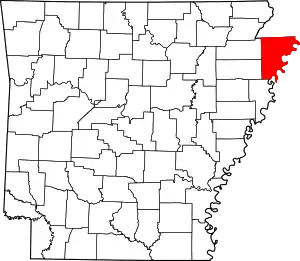 Map of Arkansas highlighting Mississippi County | |
| Towns | ||
| CDP | ||
| Unincorporated communities | ||
| Footnotes | ‡This populated place also has portions in an adjacent county or counties | |
This article is issued from Wikipedia. The text is licensed under Creative Commons - Attribution - Sharealike. Additional terms may apply for the media files.