Dashti County
Persian: شهرستان دشتی | |
|---|---|
County | |
 Location of Dashti County in Bushehr province (center, pink) | |
 Location of Bushehr province in Iran | |
| Coordinates: 28°25′N 51°37′E / 28.417°N 51.617°E[1] | |
| Country | |
| Province | Bushehr |
| Capital | Khormoj |
| Districts | Central, Kaki, Shonbeh and Tasuj |
| Area | |
| • Total | 5,008 km2 (1,934 sq mi) |
| Population (2016)[2] | |
| • Total | 86,319 |
| • Density | 17/km2 (45/sq mi) |
| Time zone | UTC+3:30 (IRST) |
| Dashti County can be found at GEOnet Names Server, at this link, by opening the Advanced Search box, entering "9206094" in the "Unique Feature Id" form, and clicking on "Search Database". | |
Dashti County (Persian: شهرستان دشتی) is in Bushehr province, Iran. Its capital is the city of Khormoj.
At the 2006 census, the county's population was 71,285 in 15,465 households.[3] The following census in 2011 counted 77,530 people in 19,697 households.[4] At the 2016 census, the county's population was 86,319 in 24,474 households.[2] The people are Muslim and speak various forms of Persian languages, including Farsi and the local Dashti.
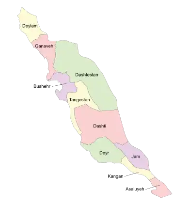
Dashti County is bounded by the Persian Gulf to the west, Tangestan County to the north and west, Dashtestan County to the northeast, Dayyer County and Kangan County and to the south, Jam County to the southeast, and Firuzabad County to the east.
Dashti County has a 25 km coastline along the Persian Gulf, with a climate that is mostly arid or semiarid. The highest point in the county is Mount Beyrami at 1,950 m. Petroleum, natural gas, lime, and stone from quarries are extracted in the county. Wheat, tomatoes, corn, and other grains are grown. There is a local honey industry.
Administrative divisions
The population history and structural changes of Dashti County's administrative divisions over three consecutive censuses are shown in the following table. The latest census shows three districts, seven rural districts, and four cities.[2]
| Administrative Divisions | 2006[3] | 2011[4] | 2016[2] |
|---|---|---|---|
| Central District | 41,179 | 45,214 | 51,625 |
| Khvormuj RD | 4,181 | 4,486 | 4,549 |
| Markazi RD | 5,331 | 5,784 | 6,354 |
| Khormoj (city) | 31,667 | 34,944 | 40,722 |
| Kaki District | 22,798 | 23,157 | 25,283 |
| Cheghapur RD | 5,391 | 5,261 | 1,581 |
| Kabgan RD | 4,850 | 5,096 | 4,657 |
| Kaki RD | 2,664 | 2,644 | 2,898 |
| Baduleh (city) | 4,028 | ||
| Kaki (city) | 9,893 | 10,156 | 12,119 |
| Shonbeh and Tasuj District | 7,308 | 7,903 | 8,621 |
| Shonbeh RD | 6,361 | 4,454 | 4,808 |
| Tasuj RD | 947 | 921 | 1,066 |
| Shonbeh (city) | 2,528 | 2,747 | |
| Total | 71,285 | 77,530 | 86,319 |
| RD: Rural District | |||
Tourist attractions
- Khormooj fortress
- Dokhtar fortress, located in Lavar-e saheli village
- Darab khan fortress, located in Shonbeh village
- Bahman dan fortress, located in Kaki city
- Mond temple
- Shirine building
- Mond River
- Mount Beyremi
- Mir Aram tomb
- Seyyed Mohammad Amin tomb, located in Kaki city
- Pir hashem tomb, located in Jabri village
- Shahzade Mohammad tomb, located in Sheikhyan village
- Dike Dojhtar, located in the Kaki city
- Baghan village
- Laver-e sharqi village
2013 Dashti County earthquake
A strong earthquake measuring 6.1 on the Richter scale struck the town of Shonbeh and villages of Shonbeh and Tasuj District in Dashti County on 9 April 2013, killing at least thirty-seven people. [5]
References
- ↑ OpenStreetMap contributors (30 March 2023). "Central District (Dashti County)" (Map). OpenStreetMap. Retrieved 30 March 2023.
- 1 2 3 4 "Census of the Islamic Republic of Iran, 1395 (2016)". AMAR (in Persian). The Statistical Center of Iran. p. 18. Archived from the original (Excel) on 3 August 2017. Retrieved 19 December 2022.
- 1 2 "Census of the Islamic Republic of Iran, 1385 (2006)". AMAR (in Persian). The Statistical Center of Iran. p. 18. Archived from the original (Excel) on 20 September 2011. Retrieved 25 September 2022.
- 1 2 "Census of the Islamic Republic of Iran, 1390 (2011)". Syracuse University (in Persian). The Statistical Center of Iran. p. 18. Archived from the original (Excel) on 3 April 2023. Retrieved 19 December 2022.
- ↑ Iran quake kills 37, injures more than 850
Bushehr Province, Iran | |||||||||||||||||||||
|---|---|---|---|---|---|---|---|---|---|---|---|---|---|---|---|---|---|---|---|---|---|
| Capital | 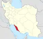 | ||||||||||||||||||||
| Counties and cities |
| ||||||||||||||||||||
| Landmarks |
| ||||||||||||||||||||
| populated places | |||||||||||||||||||||
| Capital | |||||||||||||||||||||||||||||||||
|---|---|---|---|---|---|---|---|---|---|---|---|---|---|---|---|---|---|---|---|---|---|---|---|---|---|---|---|---|---|---|---|---|---|
| Districts |
| ||||||||||||||||||||||||||||||||