Dampierre-le-Château | |
|---|---|
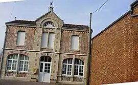 The town hall in Dampierre-le-Château | |
Location of Dampierre-le-Château | |
 Dampierre-le-Château 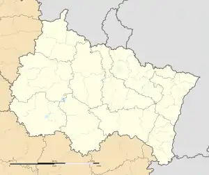 Dampierre-le-Château | |
| Coordinates: 49°00′37″N 4°47′47″E / 49.0103°N 4.7964°E | |
| Country | France |
| Region | Grand Est |
| Department | Marne |
| Arrondissement | Châlons-en-Champagne |
| Canton | Argonne Suippe et Vesle |
| Intercommunality | Argonne Champenoise |
| Government | |
| • Mayor (2020–2026) | Maxime Dausseur[1] |
| Area 1 | 11.13 km2 (4.30 sq mi) |
| Population | 116 |
| • Density | 10/km2 (27/sq mi) |
| Time zone | UTC+01:00 (CET) |
| • Summer (DST) | UTC+02:00 (CEST) |
| INSEE/Postal code | 51206 /51330 |
| 1 French Land Register data, which excludes lakes, ponds, glaciers > 1 km2 (0.386 sq mi or 247 acres) and river estuaries. | |
Dampierre-le-Château (French pronunciation: [dɑ̃pjɛʁləʃɑto]) is a commune of the Marne department in the Grand Est region of France. It is located on the Yèvre river.
History

Monument aux Morts and church
Before the French Revolution, it was called "Dampierre-en-Astenois". It was renamed "Dampierre-sur-Yèvre" in 1793, and eventually "Dampierre-le-Château" in 1801.
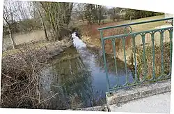
The Yèvre at Dampierre-le-Château
See also
References
- ↑ "Répertoire national des élus: les maires" (in French). data.gouv.fr, Plateforme ouverte des données publiques françaises. 13 September 2022.
- ↑ "Populations légales 2021". The National Institute of Statistics and Economic Studies. 28 December 2023.
Wikimedia Commons has media related to Dampierre-le-Château.
This article is issued from Wikipedia. The text is licensed under Creative Commons - Attribution - Sharealike. Additional terms may apply for the media files.