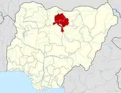
Danbatta
Dan-batta Dambarta | |
|---|---|
LGA and town | |
| Nickname: Garin Jayau | |
| Motto: Batta ka dawo | |
 Danbatta Location in Nigeria | |
| Coordinates: 12°25′59″N 8°30′55″E / 12.43306°N 8.51528°E | |
| Country | |
| State | Kano State |
| Government | |
| • Type | Multi-party democracy |
| • Honourable Chairman. | Muhammad Abdullahi Wango |
| Area | |
| • Total | 732 km2 (283 sq mi) |
| • Land | 722 km2 (279 sq mi) |
| Population (2006 census) | |
| • Total | 207,968 |
| • Density | 284.1/km2 (736/sq mi) |
| Time zone | UTC+1 (WAT) |
| 3-digit postal code prefix | 702 |
| Area code | Dbt |
| ISO 3166 code | NG.KN.DM |
Danbatta (or Dambatta or Dambarta) is a Local Government Area in Kano State, Nigeria. It is located about 49 miles north of Kano city at the Northern border of Kano state with Jigawa state. It has headquarters at Danbatta town, located on the A2 highway.
It has an approximate area of 732 km2 and a population of 207,968 at the 2006 census. It is bordered to the north and east by Kazaure and Babura Local Government areas of Jigawa State respectively, and to the south and west by Minjibir and Makoda local Government areas of Kano state respectively.
The town is the location for the Audu Bako College of Agriculture (ABCOA)[1] and Kano State School of Basic Midwifery. It is also home to Zone 3 of the Kano state Hospitals Management Board (HMB), Zonal Office of the Kano state Ministry of Education (MOE), Zonal Medical Store of Kano State Ministry of health (MOH), Zonal Office of Kano State Agricultural and Rural Development Agency (KNARDA) and Zonal Office of the Kano State Water Resources Engineering and Construction Agency (WRECA).
The postal code of the area is 702.[2]
References
- ↑ Steve Packer; Pius Elumeze; M.B. Shitu (October 2006). "State Educational Sector Project: Institutional Assessment - Kano State" (PDF). ESSPIN. Archived from the original (PDF) on 2011-07-26. Retrieved 2010-05-16.
- ↑ "Post Offices - with map of LGA". NIPOST. Archived from the original on November 26, 2012. Retrieved 2009-10-20.
