| Chaudière Falls | |
|---|---|
| French: Chutes de la Chaudière | |
.jpg.webp) | |
| Location | Lévis, Quebec |
| Coordinates | 46°42′53″N 71°16′57″W / 46.71472°N 71.28250°W[1] |
| Type | Segmented block |
| Total height | 35 metres (115 ft) |
| Total width | 240 m (790 ft) |
| Watercourse | Chaudière River |
| Average flow rate | 500 m3/s (18,000 cu ft/s)[2] |
Chaudière Falls (French: Chutes de la Chaudière) is a 35-meter-high (115 ft) waterfall in Lévis, Quebec along the Chaudière River. It is part of the regional Parc des Chutes-de-la-Chaudière, which features a 113-metre-long (371 ft) suspension footbridge standing 23 metres over the river.[3] There are walking and bicycle trails along the river.
Gallery
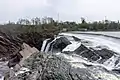 View from the top of the Chaudière Falls
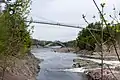 Footbridge on the Chaudière River
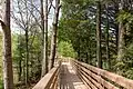 Walking trail in the park
See also
References
- ↑ Querying Geographical Names of Canada - Query by name Archived 2011-06-08 at the Wayback Machine
- ↑ "Graphique des données à une station hydrométrique". www.cehq.gouv.qc.ca. Retrieved 2020-11-04.
- ↑ "Parc des Chutes-de-la-Chaudière". Visitez Lévis. Retrieved 30 November 2016.
External links
 Media related to Chaudière Falls (Rivière Chaudière) at Wikimedia Commons
This article is issued from Wikipedia. The text is licensed under Creative Commons - Attribution - Sharealike. Additional terms may apply for the media files.