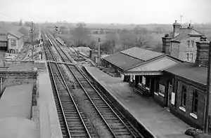
Bletchington | |
|---|---|
 The station in 1961 | |
| General information | |
| Location | Bletchington, Cherwell England |
| Grid reference | SP482182 |
| Platforms | 2 |
| Other information | |
| Status | Disused |
| History | |
| Original company | Oxford and Rugby Railway |
| Pre-grouping | Great Western Railway |
| Post-grouping | GWR |
| Key dates | |
| 1850 | Station opens |
| 2 November 1964 | Station closes for passengers |
| 21 June 1965 | closed for goods |
Bletchington railway station is a disused station in Oxfordshire at Enslow, England, a hamlet 1.25 miles (2 km) west of the village of Bletchingdon. The station had a number of names during its period of operation: 'Woodstock', 'Woodstock Road', 'Kirtlington' and finally 'Bletchington'.
History
The Oxford and Rugby Railway planned a railway between those two points, which was authorised on 4 August 1845;[1] construction began in 1846,[2] but before any portion was open, it was absorbed by the Great Western Railway. The line opened as far as Banbury on 2 September 1850, and there were three intermediate stations,[3][4] the southernmost being Woodstock Road.[3][4] Upon the opening of a different station named Woodstock Road in 1855, this station was renamed Kirtlington;[3][5][6] and following rebuilding it was renamed for a final time on 11 August 1890, becoming Bletchington.[3][5][6] It is possible that the original name of this station was Woodstock, becoming Woodstock Road in May 1851[5] or 1852.[7]
British Railways closed the station to passengers on 2 November 1964[8][7] and to goods on 21 June 1965.[8] The station building survives but much of the station site is now occupied by an industrial estate.
| Preceding station | Historical railways | Following station | ||
|---|---|---|---|---|
| Tackley Line and station open |
Great Western Railway Oxford and Rugby Railway |
Kidlington Line open, station closed | ||
Notes
- ↑ MacDermot 1927, p. 229.
- ↑ MacDermot 1927, p. 295.
- 1 2 3 4 MacDermot 1927, p. 300.
- 1 2 Simpson 1997, p. 60.
- 1 2 3 Mitchell & Smith 2003, fig. XVIII.
- 1 2 Simpson 1997, pp. 61, 85.
- 1 2 Simpson 1997, p. 85.
- 1 2 Mitchell & Smith 2003, fig. 81.
References
- MacDermot, E.T. (1927). History of the Great Western Railway. Vol. I (1st ed.). Paddington: Great Western Railway.
- Mitchell, Vic; Smith, Keith (February 2003). Didcot to Banbury. Western Main Lines. Midhurst: Middleton Press. ISBN 1-904474-02-0.
- Simpson, Bill (1997). A History of the Railways of Oxfordshire. Vol. Part 1: The North. Banbury and Witney: Lamplight. ISBN 1-899246-02-9.
External links
51°51′38″N 1°18′03″W / 51.86059°N 1.30091°W