| Beagle Commonwealth Marine Reserve | |
|---|---|
IUCN category VI (protected area with sustainable use of natural resources) | |
Map showing the Beagle Commonwealth Marine Reserve | |
| Location | Bass Strait, Australia |
| Nearest town | Tidal River, Victoria |
| Coordinates | 39°20′S 147°07′E / 39.34°S 147.12°E[1] |
| Area | 2,928 km2 (1,131 sq mi) |
| Established | 31 August 2007 |
| Governing body | Parks Australia (Commonwealth of Australia) |
| environment | |
Beagle Commonwealth Marine Reserve is a 2,928 km2 marine protected area within Australian waters located in Bass Strait off the coast of Victoria and near Tasmania's Flinders Island. The reserve was established in 2007[2] and is part of the South-east Commonwealth Marine Reserve Network.
The reserve boundaries enclose Kent Group National Park and the Hogan and Curtis Island groups. Nearby to the north-east is Wilsons Promontory Marine National Park. The reserve represents an area of shallow continental shelf ecosystems in depths of about 50–70 m (160–230 ft), the sea floor that it covers formed part of a land bridge between Tasmania and Victoria during the last ice age 10 000 years ago.[3]
Protection
The entirety of the Beagle marine reserve is IUCN protected area category VI and zoned as 'Multiple Use'.[3]
| Zone | IUCN | Activities permitted | Area (km2) | |||||||||||||||||||||||||||||||||||||||||||||||||||||||||||||||||||||||||||||||||||||||||||||||
|---|---|---|---|---|---|---|---|---|---|---|---|---|---|---|---|---|---|---|---|---|---|---|---|---|---|---|---|---|---|---|---|---|---|---|---|---|---|---|---|---|---|---|---|---|---|---|---|---|---|---|---|---|---|---|---|---|---|---|---|---|---|---|---|---|---|---|---|---|---|---|---|---|---|---|---|---|---|---|---|---|---|---|---|---|---|---|---|---|---|---|---|---|---|---|---|---|---|---|
| Recreational fishing | Commercial fishing | Mining | ||||||||||||||||||||||||||||||||||||||||||||||||||||||||||||||||||||||||||||||||||||||||||||||||
| Multiple Use | VI | Yes | with approval | with approval | 2,928 | |||||||||||||||||||||||||||||||||||||||||||||||||||||||||||||||||||||||||||||||||||||||||||||
| [Note 1] | ||||||||||||||||||||||||||||||||||||||||||||||||||||||||||||||||||||||||||||||||||||||||||||||||||
Shipwrecks
Located within the Beagle marine reserve are the wrecks of the SS Cambridge (sunk by German WWII mine) and Eliza Davis, both are east of Wilson's Promontory.[3]
Gallery
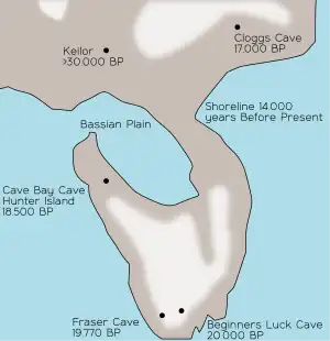 The Bassian Plain was a land bridge that connected Tasmania to mainland Australia
See also
Notes
References
- ↑ "Beagle Commonwealth Marine Reserve on OpenStreetMap". openstreetmap.org. OpenStreetMap contributors. Retrieved 17 June 2017.
- ↑ "Collaborative Australian Protected Areas Database (CAPAD) 2014 - Marine". environment.gov.au. © Commonwealth of Australia. Retrieved 16 June 2017.
- 1 2 3 "Beagle Commonwealth Marine Reserve". environment.gov.au. © Commonwealth of Australia. Retrieved 17 June 2017.
- ↑ "South-east Commonwealth Marine Reserves Network - Zoning and activities". environment.gov.au. © Commonwealth of Australia. Retrieved 16 June 2017.