 | |
| Length | 0.6 km (0.37 mi) |
|---|---|
| Location | Auckland CBD, New Zealand |
| Postal code | 1010 |
| North end | Beach Road |
| South end | Symonds Street |
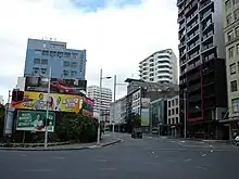
Anzac Avenue is a street in Auckland, New Zealand's most populous city. It was constructed between 1914 and 1919 to link Beach Road to Symonds Street, and was named as a memorial to the troops who died in the Gallipoli campaign.[1]
History

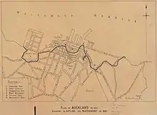
Anzac Avenue and neighbouring Beach Road follow the shape of the original shoreline of the Auckland waterfront, leading from Symonds Street towards the Point Britomart headland, passing alongside Official Bay and Mechanics Bay. Land reclamations of the harbour began in the 1860s, changing the landscape. Anzac Avenue was originally the location of Te Hororoa Pā, a name which name refers to an incident where part of the pā site slipped into the ocean.[2] In the 1740s, the Waiōhua settlement at Te Hororoa was one of the final to fall during Waiohua's defeat to Ngāti Whātua.[3]
Anzac Avenue, which started construction in 1914,[1] followed the route of Jermyn Street, but was renamed in 1916 to form a memorial to those who had died at Gallipoli, overriding a recommendation to call it Jellicoe Street.[4] There was an objection to the renaming, because the previous name honoured Captain John Jermyn Symonds, an early resident of the street and figure in the early history of Auckland.[5] A commemoration of the construction of the road was held in 1918, where the Governor-General, Arthur Foljambe, planted two pūriri trees at the corner of Anzac Avenue and Waterloo Quadrant, and a score of trees were planted by others.[6] The road was described as busy in 1919 even before it was fully completed.[7] A tramline along Anzac Avenue was opened in February 1921.[8]
Demographics
The statistical area of Anzac Avenue, which is bounded by Beach Road, Parliament Street, Waterloo Quadrant, Princes Street and Emily Place, covers 0.10 km2 (0.039 sq mi)[9] and had an estimated population of 2,820 as of June 2022,[10] with a population density of 28,200 people per km2.
| Year | Pop. | ±% p.a. |
|---|---|---|
| 2006 | 2,124 | — |
| 2013 | 2,568 | +2.75% |
| 2018 | 2,748 | +1.36% |
| Source: [11] | ||
Anzac Avenue had a population of 2,748 at the 2018 New Zealand census, an increase of 180 people (7.0%) since the 2013 census, and an increase of 624 people (29.4%) since the 2006 census. There were 1,458 households, comprising 1,422 males and 1,323 females, giving a sex ratio of 1.07 males per female. The median age was 30.6 years (compared with 37.4 years nationally), with 90 people (3.3%) aged under 15 years, 1,215 (44.2%) aged 15 to 29, 1,269 (46.2%) aged 30 to 64, and 168 (6.1%) aged 65 or older.
Ethnicities were 45.9% European/Pākehā, 4.4% Māori, 2.6% Pacific peoples, 44.4% Asian, and 8.8% other ethnicities. People may identify with more than one ethnicity.
The percentage of people born overseas was 66.5, compared with 27.1% nationally.
Although some people chose not to answer the census's question about religious affiliation, 54.9% had no religion, 24.7% were Christian, 0.2% had Māori religious beliefs, 5.1% were Hindu, 3.2% were Muslim, 3.8% were Buddhist and 3.8% had other religions.
Of those at least 15 years old, 1,320 (49.7%) people had a bachelor's or higher degree, and 90 (3.4%) people had no formal qualifications. The median income was $37,200, compared with $31,800 nationally. 600 people (22.6%) earned over $70,000 compared to 17.2% nationally. The employment status of those at least 15 was that 1,527 (57.4%) people were employed full-time, 363 (13.7%) were part-time, and 135 (5.1%) were unemployed.[11]
Notable locations

- Brooklyn Flats, 66–70 Emily Place, 1936, apartment block.[12]
- Eden Hall, 3 Eden Crescent, 1936, apartment block.[13]
- Logan Bank, 114 Anzac Avenue, 1917, remnants of a house built 1871 and occupied by John Logan Campbell, used as support for the construction of Anzac Avenue.[14]
- Station Hotel, 122 Anzac Avenue, 1931, hotel fronting on both Beach Road and Anzac Avenue.[15]
- Berrisville Flats, 152 Anzac Avenue, 1937, apartment block.[16]
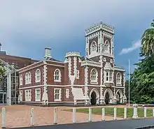
- High Court Building, corner Anzac Avenue and Waterloo Crescent, 1868, originally the Supreme Court building, built in Gothic Revival style.[17]
- Braemar, 7 Parliament Street, 1901, apartment complex.[18]
- Middle Courtville, 9 Parliament Street, 1914, apartment complex.[19]
- Corner Courtville, 11 Parliament Street, 1919, apartment complex.[20]
References
- 1 2 "Anzac Avenue, Auckland". New Zealand Ministry for Culture and Heritage. Retrieved 26 July 2020.
- ↑ Campbell, Dr Nerida; Truttman, Lisa; Auckland City Council; Ngāti Pāoa; Ngāti Whātua-o-Ōrākei. "Auckland's Original Shoreline" (PDF). Auckland Council. Retrieved 24 September 2021.
- ↑ Blair, Ngarimu (2 June 2021). "Statement of evidence of Ngarimu Alan Huiroa Blair on behalf of the plaintiff" (PDF). Ngāti Whātua-o-Ōrākei. Archived from the original (PDF) on 2 August 2021. Retrieved 24 September 2021.
- ↑ "Memory of Brave Men". New Zealand Herald. 1 December 1916. p. 9.
- ↑ "Changed Name Deplored". New Zealand Herald. 29 June 1917. p. 4.
- ↑ "Anzac Avenue - Tree-planting Ceremony". New Zealand Herald. 20 September 1918. p. 6.
- ↑ "New Traffic Outlet - Anzac Avenue Much Used". Auckland Star. 10 July 1919. p. 7.
- ↑ Bush, G. W. A. (1971). Decently and in Order: The Centennial History of the Auckland City Council. Collins. p. 231.
- ↑ "ArcGIS Web Application". statsnz.maps.arcgis.com. Retrieved 12 July 2022.
- ↑ "Population estimate tables - NZ.Stat". Statistics New Zealand. Retrieved 25 October 2022.
- 1 2 "Statistical area 1 dataset for 2018 Census". Statistics New Zealand. March 2020. Anzac Avenue (134500). 2018 Census place summary: Anzac Avenue
- ↑ "Brooklyn Flats". New Zealand Heritage List/Rārangi Kōrero. Heritage New Zealand. Retrieved 26 July 2020.
- ↑ "Eden Hall". New Zealand Heritage List/Rārangi Kōrero. Heritage New Zealand. Retrieved 26 July 2020.
- ↑ "Logan Bank". New Zealand Heritage List/Rārangi Kōrero. Heritage New Zealand. Retrieved 26 July 2020.
- ↑ "Station Hotel (former)". New Zealand Heritage List/Rārangi Kōrero. Heritage New Zealand. Retrieved 26 July 2020.
- ↑ "Berrisville Flats". New Zealand Heritage List/Rārangi Kōrero. Heritage New Zealand. Retrieved 26 July 2020.
- ↑ "High Court Building". New Zealand Heritage List/Rārangi Kōrero. Heritage New Zealand. Retrieved 26 July 2020.
- ↑ "Braemar". New Zealand Heritage List/Rārangi Kōrero. Heritage New Zealand. Retrieved 26 July 2020.
- ↑ "Courtville (Middle Courtville)". New Zealand Heritage List/Rārangi Kōrero. Heritage New Zealand. Retrieved 26 July 2020.
- ↑ "Courtville (Corner Courtville)". New Zealand Heritage List/Rārangi Kōrero. Heritage New Zealand. Retrieved 26 July 2020.