Peace Country
tourist region in Alberta
This guide is about the portion of the Peace Country in Alberta. For the portion in British Columbia, see Peace Country and Northern Rockies.
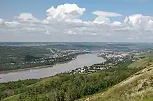
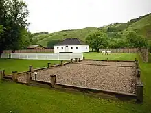
The Peace Country is a region that covers the entire northwestern quadrant of Alberta, Canada. Most of northern Alberta is part of the sparsely-populated boreal forest, but here along the banks of the Peace River, there is an isolated patch of farmland, separated from the main population centres of Alberta by the Swan Hills. This is the northernmost agricultural region of any size in North America, and is home to most of Canada's farmed bison (buffalo) and honeybees. The entire region, both farmed and forested, is drained by the "mighty Peace", a major river that goes on to empty into the world's largest inland delta at nearby Wood Buffalo National Park.
Many visitors (especially Americans) pass through this region on their way to the Alaska Highway. While here, you can blast through as fast as possible, or if you know where to look, you can find natural gems like Alberta's largest road-accessible lake (Lesser Slake Lake) or indoor actives like a huge new Dinosaur museum (Philip J. Currie Museum in Wembley).