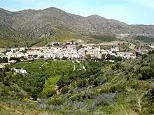
Colera
municipality in the comarca of Alt Empordà, Girona, Catalonia, Spain
Colera is in Costa Brava. It has very beautiful beaches, such as Garbet, Borró, Assutzenes, Portes, Morts, Goixa, Carbassó and Cala Rovellada.
- For the infectious disease, see Cholera
Understand
It is a coastal town, located between Llançà and Portbou, on the northern Costa Brava; and the main economy it has is tourism.
Tourist office
- 🌍 Tourist office, Labrun 34, ☏ +34 972 389 050, ajuntament@colera.cat. M-F 09:00-14:00. (updated Mar 2024)
Get in
By plane
The nearest airports are Girona-Costa Brava (GRO, in Spain) and Perpignan–Rivesaltes (PGF, In France)
By train
The RG1 (Rodalies Girona RENFE) stops in the station. Also de R11 (regional service RENFE-Rodalies).
In Figueres Vilafant station (Figueres) you can connect the high speed train connection to Madrid, Barcelona and Paris.
- 🌍 Colera station (Estació de Colera). Barcelona–Girona–Portbou railway, lines RG1 and R11 (updated Mar 2024)
By bus
By car
- From France: The A-9 from Montpellier and Perpignan to the Spanish border. Then the AP7 until Figueres.
- From Barcelona and Girona: The AP7 until Figueres.
- From Figueres take N-260 to Colera.
- From Perpignan you can take the D914 to Portbou and then Colera. From Port Vendres Its a local road full of curves.
By boat
- 🌍 Port de Colera (Club Nàutic Sant Miquel de Colera), ☏ +34 621 27 98 04. The port has public service offices, toilets and showers, water and electricity at each berth for each mooring, ice sale. It has a crane for loading and unloading boats. To use the service, contact the club offices. (updated Mar 2024)
Get around
The village is small enough to walk around.
See
- 🌍 church of Sant Miquel de Colera. The town of Sant Miquel de Colera was built anew at the end of the 18th century. During the Civil War (1936-39), the entire area of the church was destroyed by bombing. Many of the houses that surrounded the temple were rebuilt, while the church had to be redone again. (updated Mar 2024)
- 🌍 Castell de Molinàs. It is about the ruined remains of the Molinàs castle tower. A rectangular enclosure can be seen, of which two building bodies are preserved. The perimeter walls of the fortification have been preserved irregularly. The characteristics of the building, the castle tower, for the diaphragm arcades, for the interior rooms and the appearance of other elements, such as the tall arrowheads and the matacà, probably date back to the late medieval period, perhaps from the 12th century or early 13th century. It is a construction of a popular and rustic nature that takes advantage of the remains of a large tower or watchtower much earlier (updated Mar 2024)
- 🌍 Molinàs. Molinàs is an uninhabited population center. This place was born at the same time as Sant Miquel de Colera in the last third of the 18th century. The neighborhood was depopulated 200 years later, due to ravages and calamities such as phylloxera or the 1956 frost (updated Mar 2024)
- 🌍 old Sant Miquel de Colera hermitage. it was the old parish church of the town of Colera in Alt Empordà, until it was moved to the seaside in the 18th century. The first certain news of the temple are from the 11th century. (updated Mar 2024)
Viewpoints
Do
Beach
- 🌍 Platja del Borró (Platja d'Assutzenes) (access is by a short path that goes down from the N-260 road, or by the Camí de ronda from Garbet beach.). It has a length of 93 m and an average width of 18 m, of fine sand, gravel and pebbles. The name Assutzenes refers to another plant that grows there, the white lily (Lilium candidum). (updated Mar 2024)
- 🌍 Platja del Borró d'enfora (it can be reached by walking from Borró beach.). It has a length of about 100 m and an average width of 10 m, of coarse sand, and is separated into two coves by some rocks that almost reach the sea. It is a nudist beach. It can be reached by walking from Borró beach. (updated Mar 2024)
- 🌍 Platja d'en Carbassó. It has a length of 45 m and a width of 5 m. Oriented to the southeast, the surface of the beach is composed of thick, dark-colored sand. (updated Mar 2024)
- 🌍 Platja de Garbet (there is a paid municipal car park). Made up of sand, gravel and pebbles. It has a width of 33 meters and a length of 449 meters. In its central sector there is an incipient climbing dune. This beach faces east and is at the bottom of a large bay with the same name: Garbet Bay. At the southern end there is a rock in the sea called Cavall Bernat. (updated Mar 2024)
- 🌍 Platja d'en Goixa. It is an urban beach. bounded to the north by a rocky outcrop and to the south by Playa dels Morts. It has a length of 147.7 m and an average width of 15.7 m, with very coarse sand and a moderate entrance slope to the water. (updated Mar 2024)
- 🌍 Platja dels Morts. it is an urban beach, limited to the north by Goixa Beach, and to the south by Portes Beach and Port de Colera. It has a length of 154.7 m and an average width of 38.6 m, of sand, gravel and pebbles. It has all the usual services in an urban beach. There is a beach bar on the beach itself and numerous restaurants on the promenade a few meters to the right. (updated Mar 2024)
- 🌍 Platja del Port d'en Joan (in Garbet Bay, 200 m east of Garbet Beach). It is divided into two sectors, separated by rocks, of 61 and 26 m in length, respectively. It is oriented to the southeast, the surface of the cove is composed of gravel, grey in colour. (updated Mar 2024)
- 🌍 Platja de les Portes (platja de les Barques). It is an urban beach in the municipality of Colera (Alt Empordà) located in the bay of Colera, in the urban core, bordering the beach of the Dead to the north and the port of Colera to the southeast. It is the town's main beach, which runs parallel to the promenade and has all kinds of services. It has a length of 130 m and an average width of 30 m, of medium-grained sand. It has an area suitable for dogs. (updated Mar 2024)
- 🌍 Platja de la Rovellada (Cala Rovellada). Rovellada beach is a small semi-urban beach in the housing estate of the same name, one kilometer northeast of the city center. It has a length of 40 meters and a width of 10 m. It is made up of dark colored pebbles. It is oriented to the south, protected from the north wind. (updated Mar 2024)
- 🌍 Platja de Sota d'en Navata (it can be accessed on foot by going down about 150 m from the N-260 road). In Garbet Bay, between Garbet Beach and Borró Beach, at the foot of a cliff. It has a length of 90 m, gravel and pebbles. (updated Mar 2024)
Hiking
- The GR92 crosses the city
Buy
Every Monday there is a market. In summertime placed in Plaça dels Països Catalans, and in winter located in Plaça de Javier Ugarte – C/ Horts
- 🌍 Celler Hugas de Batlle (wine shop), C/ Francesc Ribera, 28, ☏ +34 972 389 149. (updated Mar 2024)
Eat
- 🌍 Mont-Mercè, C/ Mar, 109, ☏ +34 972 389 126. (updated Mar 2024)
- 🌍 la Llesca. (updated Mar 2024)
- 🌍 Passi Passi. (updated Mar 2024)
- 🌍 El Jovent, C/ Francesc Ribera, 16, ☏ +34 972 389 009. (updated Mar 2024)
- Restaurant Can Llissa, Urbanització Sant Miquel, ☏ +34 972 389 018. (updated Mar 2024)
Drink
Sleep
- 🌍 Hostal La gambina, Passeig Marítim 5, ☏ +34 972 12 8112. ☏ +34 972 38 9172. (updated Mar 2024)
- 🌍 Hostal Restaurant TotsSomPops, Av./ 11 de Setembre, 7, ☏ +34 972 389 196. (updated Mar 2024)
- 🌍 Mont Mercè, C/ Mar, 109, ☏ +34 972 389 126. (updated Mar 2024)
Campgrounds
- 🌍 Càmping Sant Miquel, Pla de les Portes, 1, ☏ +34 972 38 90 18, info@yellohvillage-santmiquel.com. open from Easter until late September. (updated Mar 2024)