Pamirs
mountain range in Central Asia
The Pamir mountains, or Pamirs or Pamir Knot, is a large region of high ground at the junction of several other mountain ranges of which the best-known is the Himalayas. The terrain is difficult and the population sparse. There are several mountains over 7,000 m (higher than anything outside the Greater Himalaya region) and some large glaciers.
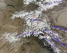
This article covers only the part of the range in Tajikistan, officially the Gorno-Badakhshan Autonomous Region. However, the Pamir range extends across borders; see Northeast Afghanistan and Northwest Pakistan for the parts in other countries. The Ferghana Valley region of Kyrgyzstan runs along the northern edge of the Pamirs and one end of the Pamir Highway is the Krygyz town of Osh.
- 🌍 Badakhshan. This historical state's territory was the Pamirs. The history is long; Badakshan gemstones (lapis lazuli and spinel) were mined before 6000 BCE, and were traded at least as far as the Indus Valley Civilisation and Ancient Mesopotamia before 2000 BCE. Both gems are still mined there today.
The history is also complex; over the centuries Badakhshan was conquered by or allied with a whole range of nearby states. Today most of it is divided between Badakhshan Province in northern Afghanistan and Gorno-Badakhshan in southern Tajikistan, with a small piece now in China.
Nearby regions with relatively flat land and denser population are the area around Kashgar (China) to the east, the Ferghana Valley (Tajikistan, Uzbekistan and Kyrgyzstan]) to the north, and Bactria (Tajikistan, Afghanistan and Uzbekistan) to the west. The main route of the historic Silk Road ran from Kashgar through a pass just north of the Pamirs into the Ferghana Valley and through it to Samarkand. Central Afghanistan is to the south, with the Hindu Kush range (a spur off the Pamirs) as its northern boundary.
The Pamir River starts in the Pamirs and leads down to Bactria where it joins several other tributaries to form one of the region's greatest rivers, now called the Amu Darya but known in ancient times as the Oxus. Further north, in the Ferghana Valley, other rivers that start in the Pamirs combine to form the Syr Daria, known in ancient times as the Jaxartes.
Alexander the Great stopped at the edge of the Pamirs; he took Transoxania (north of the Oxus) and the Jaxartes became his northern border. The Mongol Empire also took nearby areas but did not much intrude into the mountains. The Persian Empire and later the Russian Empire, however, did take control in these mountains as well as nearby lowlands. The British Raj nibbled at the southern edge, taking parts of the range that are now in Pakistan.