Yunmeng County
云梦县 | |
|---|---|
 Yunmeng railway station | |
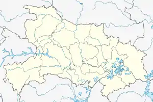
 Yunmeng Location of the seat in Hubei | |
| Coordinates (Yunmeng government): 31°01′16″N 113°45′14″E / 31.021°N 113.754°E | |
| Country | People's Republic of China |
| Province | Hubei |
| Prefecture-level city | Xiaogan |
| Population (2010)[1] | |
| • Total | 524,799 |
| Time zone | UTC+8 (China Standard) |
| Postal code | 432500 |
| Website | www |
Yunmeng County[2] (simplified Chinese: 云梦县; traditional Chinese: 雲夢縣; pinyin: Yúnmèng Xiàn) is a county in eastern Hubei province, People's Republic of China. It is administered by Xiaogan City and is located just outside Xiaogan's urban area.
History


During the Spring and Autumn period of Chinese history (770-476 BCE), Yunmeng County formed part of the Zhou Dynasty vassal State of Yun, later annexed by the State of Chu whose kings used the area as a hunting ground. After Chu's defeat at the hands of the State of Qin in 223 BCE, Yunmeng became part of Qin territory. Legend suggests that China's first emperor Qin Shi Huang visited the county in 219 BCE. Yunmeng was the location of the Jiangxia Commandery of the Han Dynasty and the cradle of the Chinese Huang Clan.
Administrative divisions

- Chengguan (城关镇), Yitang (义堂镇), Zengdian (曾店镇), Wupu (吴铺镇), Wuluo (伍洛镇), Xiaxindian (下辛店镇), Daoqiao (道桥镇), Geputan (隔蒲潭镇), Hujindian (胡金店镇)
Townships:
Other area:
Climate
| Climate data for Yunmeng (1991–2020 normals, extremes 1981–2010) | |||||||||||||
|---|---|---|---|---|---|---|---|---|---|---|---|---|---|
| Month | Jan | Feb | Mar | Apr | May | Jun | Jul | Aug | Sep | Oct | Nov | Dec | Year |
| Record high °C (°F) | 19.2 (66.6) |
27.0 (80.6) |
31.5 (88.7) |
33.3 (91.9) |
36.2 (97.2) |
36.6 (97.9) |
38.3 (100.9) |
38.6 (101.5) |
37.0 (98.6) |
34.4 (93.9) |
28.6 (83.5) |
21.2 (70.2) |
38.6 (101.5) |
| Mean daily maximum °C (°F) | 8.0 (46.4) |
11.1 (52.0) |
16.0 (60.8) |
22.5 (72.5) |
27.1 (80.8) |
30.0 (86.0) |
32.5 (90.5) |
32.4 (90.3) |
28.8 (83.8) |
23.2 (73.8) |
16.8 (62.2) |
10.4 (50.7) |
21.6 (70.8) |
| Daily mean °C (°F) | 3.7 (38.7) |
6.5 (43.7) |
11.2 (52.2) |
17.3 (63.1) |
22.4 (72.3) |
25.9 (78.6) |
28.5 (83.3) |
27.8 (82.0) |
23.6 (74.5) |
17.9 (64.2) |
11.6 (52.9) |
5.7 (42.3) |
16.8 (62.3) |
| Mean daily minimum °C (°F) | 0.5 (32.9) |
2.9 (37.2) |
7.2 (45.0) |
12.9 (55.2) |
18.2 (64.8) |
22.4 (72.3) |
25.2 (77.4) |
24.3 (75.7) |
19.8 (67.6) |
13.9 (57.0) |
7.6 (45.7) |
2.1 (35.8) |
13.1 (55.6) |
| Record low °C (°F) | −11.0 (12.2) |
−8.0 (17.6) |
−3.5 (25.7) |
0.0 (32.0) |
7.9 (46.2) |
12.3 (54.1) |
18.6 (65.5) |
15.6 (60.1) |
10.7 (51.3) |
1.4 (34.5) |
−3.5 (25.7) |
−13.0 (8.6) |
−13.0 (8.6) |
| Average precipitation mm (inches) | 38.2 (1.50) |
46.3 (1.82) |
68.3 (2.69) |
107.0 (4.21) |
135.7 (5.34) |
178.6 (7.03) |
201.3 (7.93) |
119.2 (4.69) |
68.2 (2.69) |
62.9 (2.48) |
47.6 (1.87) |
23.1 (0.91) |
1,096.4 (43.16) |
| Average precipitation days (≥ 0.1 mm) | 7.9 | 9.3 | 10.9 | 10.5 | 11.7 | 10.6 | 10.5 | 9.5 | 7.5 | 9.0 | 8.4 | 6.9 | 112.7 |
| Average snowy days | 4.2 | 2.3 | 0.9 | 0 | 0 | 0 | 0 | 0 | 0 | 0 | 0.4 | 1.3 | 9.1 |
| Average relative humidity (%) | 74 | 75 | 75 | 75 | 76 | 81 | 82 | 81 | 77 | 75 | 75 | 73 | 77 |
| Mean monthly sunshine hours | 96.7 | 94.8 | 125.7 | 152.5 | 167.2 | 158.1 | 206.8 | 211.9 | 161.8 | 144.6 | 123.4 | 112.5 | 1,756 |
| Percent possible sunshine | 30 | 30 | 34 | 39 | 39 | 37 | 48 | 52 | 44 | 41 | 39 | 36 | 39 |
| Source: China Meteorological Administration[5][6] | |||||||||||||
Culture
Yumian (Chinese: 鱼面; lit. 'fish noodle'), is a local specialty noodle made with flour and fish from the Fu River in Yunmeng. Yunmeng Yumian was awarded silver medal of The first Panama–Pacific International Exposition in 1915.[7][8]
Notable people
- Dou Ziwen (斗子文)
- Huang Xiang (黄香)
- Zhao Fu (赵复)
- Zou Guanguang (邹观光)
- Xu Zhaochun (许兆椿)
- Wu Luzhen (吴禄贞)
External links
References
- 1 2 云梦县历史沿革 [Yunmeng County Historical Development]. XZQH.org. 6 August 2014. Retrieved 25 April 2018.
2010年第六次人口普查,云梦县常住总人口524799人,其中:城关镇137873人,义堂镇40180人,曾店镇31059人,吴铺镇28399人,伍洛镇35006人,下辛店镇47870人,道桥镇21978人,隔蒲潭镇51137人,胡金店镇27439人,倒店乡27222人,沙河乡31241人,清明河乡24697人,云梦县经济开发区20698人。
- 1 2 http://cn.bing.com/maps Yunmeng County Yitang Town Zengdian Town Wupu Town Wuluo Town Daoqiao Town Geputan Town Hujindian Town Qingminghe Town
- ↑ 2016年统计用区划代码和城乡划分代码:云梦县 [2016 Statistical Area Numbers and Rural-Urban Area Numbers: Yunmeng County] (in Simplified Chinese). National Bureau of Statistics of the People's Republic of China. 2016. Retrieved 25 April 2018.
统计用区划代码 名称 420923100000 城关镇 420923101000 义堂镇 420923102000 曾店镇 420923103000 吴铺镇 420923104000 伍洛镇 420923105000 下辛店镇 420923106000 道桥镇 420923107000 隔蒲潭镇 420923108000 胡金店镇 420923200000 倒店乡 420923201000 沙河乡 420923202000 清明河乡 420923450000 县经济开发区
- ↑ 乡镇动态 [Status of Township-level Divisions] (in Simplified Chinese). Yunmen County People's Government. Retrieved 25 April 2018.
开发区 城关镇 吴铺镇 伍洛镇 沙河乡 下辛店镇 道桥镇 隔蒲潭镇 清明河乡 胡金店镇 义堂镇 倒店乡 曾店镇
- ↑ 中国气象数据网 – WeatherBk Data (in Simplified Chinese). China Meteorological Administration. Retrieved 23 September 2023.
- ↑ 中国气象数据网 (in Simplified Chinese). China Meteorological Administration. Retrieved 23 September 2023.
- ↑ 1911年鱼面作为云梦名产参加巴拿马举行的万国博览会,以“银丝鱼面”获银质奖. boyar.cn (in Simplified Chinese). 2009-11-05.
- ↑ 百年前的1915年,云梦鱼面就在巴拿马万国博览会上荣获银质奖 (in Simplified Chinese). Yunmeng County People's Government. 2017-06-05.