.jpg.webp)

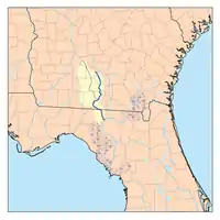
The Withlacoochee River originates in Georgia, northwest of Nashville, Georgia. It flows south through Berrien County where it joins the New River and forms part of the boundary between Berrien and Cook counties. It then flows south into Lowndes County, Georgia. At Troupville, Georgia the Little River joins the Withlacoochee River flows continues to flow south and forms part of the boundary between Lowndes and Brooks counties in Georgia. The river then flows into Florida for 1.34 miles before returning into Georgia for an additional 2.44 miles. It then returns to Florida, forming the northeast boundary of Madison County, Florida and the western boundary of Hamilton County, Florida and eventually merges with the Suwannee at Suwannee River State Park west of Live Oak. The river is 115 miles (185 km) long.[1] It is believed to be the source for the name of the central Florida river of the same name.
Etymology
The Withlacoochee River received its name from the Muskogean peoples who inhabited South Georgia. It comes from the compound Creek word ue-rakkuce [IPA: wiɬakːut͡ʃi], from ue "water", rakko "big", and -uce "small", with the rough translation "little river."[2][3] English speakers then changed the Muskogee voiceless lateral spelled r to "thl".
Crossings
Notes
- ↑ U.S. Geological Survey. National Hydrography Dataset high-resolution flowline data. The National Map, accessed April 18, 2011
- ↑ Simpson, J. Clarence (1956). Mark F. Boyd (ed.). Florida Place-Names of Indian Derivation. Tallahassee, Florida: Florida Geological Survey.
- ↑ Martin, Jack B.; Mauldin, Margaret McKane (2004-12-01). A Dictionary of Creek/Muskogee. U of Nebraska Press. p. 183. ISBN 0803283024.
- ↑ "Sponsors up and down I-75 on Water Trail Brochures | WWALS Watershed Coalition (WWALS) is Suwannee RIVERKEEPER®".
External links
- Withlacoochee River (North) Canoe Trail at Florida Department of Environmental Protection
- Rivers that flow north at EcoFlorida
- Withlacoochee River (North): Georgia State Line to Suwannee River State Park at Trails.com
30°23′14.2″N 83°10′17.9″W / 30.387278°N 83.171639°W


_SR_150.jpg.webp)
