U.S. Highway 64 | ||||
|---|---|---|---|---|
US 64 highlighted in red | ||||
| Route information | ||||
| Maintained by ArDOT | ||||
| Length | 246.35 mi[1] (396.46 km) | |||
| Existed | 1926–present | |||
| Major junctions | ||||
| West end | ||||
| East end | ||||
| Location | ||||
| Country | United States | |||
| State | Arkansas | |||
| Counties | Sebastian, Crawford, Franklin, Johnson, Pope, Conway, Faulkner, White, Woodruff, Cross, Crittenden | |||
| Highway system | ||||
| ||||

U.S. Route 64 is a U.S. highway running from Teec Nos Pos, Arizona east to Nags Head, North Carolina. In the U.S. state of Arkansas, the route runs 246.35 miles (396.46 km) from the Oklahoma border in Fort Smith east to the Tennessee border in Memphis.[1] The route passes through several cities and towns, including Fort Smith, Clarksville, Russellville, Conway, Searcy, and West Memphis. US 64 runs parallel to Interstate 40 until Conway, when I-40 takes a more southerly route.
Route description
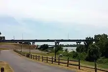

US 64 crosses Arkansas' western border over the Arkansas River, heading southeast into downtown Ft. Smith. Upon entry to Arkansas, the highway passes the Fort Smith National Historic Site, Ft. Smith Confederate Monument, Commercial Hotel and the West Garrison Avenue Historic District, all on the National Register of Historic Places. The highway turns northwest near the New Theatre, following the Arkansas and Missouri Railroad and concurring with US 71 Business onto 10th and 11th Streets.[2] Westbound traffic runs on 10th St and eastbound traffic on 11th St past the Fort Smith Masonic Temple. Traffic converges onto Midland Boulevard.[3] US 64 crosses the Arkansas River again near the American Doughboy Monument as it enters Van Buren on Broadway. US 64 passes the Van Buren Post Office before turning east onto Main Street, then northeast again becoming the Alma Highway. US 64 passes a former alignment, now designated as Oak St. After Oak St, US 64 crosses I-540 and continues east to Alma.[4] US 64 closely follows Interstate 40 until Conway, while also closely following the Arkansas River, the Union Pacific Railroad, and the southern edge of the Ozark National Forest.
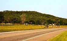
US 64 continues through mountainous Franklin County, intersecting the Pig Trail Scenic Byway in Ozark.[5] The route passes the Franklin County Courthouse, and the Ozark Courthouse Square Historic District in Ozark before exiting town continuing east. Route 64 passes a historically significant connector road in Wiederkehr Village before entering Altus and entering Johnson County. US 64 runs through Coal Hill and Hartman before curving northeast and crossing over I-40. The route continues to Clarksville, home of the University of the Ozarks.[6] The route passes the Johnson County Courthouse, historic American Legion Hut, Clarksville Municipal Airport, and Lake Dardanelle before again crossing over I-40 and entering Pope County.[7]
US 64 then parallels Interstate 40, through Russellville and Morrilton. In Faulkner County, it briefly converges with U.S. Route 65B through Conway heading south before diverging from US 65 Business and Interstate 40 by turning east onto Oak Street. The highway next approaches Vilonia, following a southerly bypass around the city that opened in October 2011[8] (replacing its former alignment along Vilonia's Main Street) and rejoining its prior alignment west of the White County line and continuing to El Paso, where it intersects Arkansas Highway 5. US 64 then travels east to Beebe, where it originally entered town via Center Street and joined with US 67 and US 167. This former route along Center Street has since been resigned U.S. Route 67B,[9] as all three US highways have been relocated to a concurrent divided highway northwest of Beebe.
US 64 runs along this divided highway past McRae, Garner, and Searcy, where its original route took it north along Main Street, then east along Race Avenue. This former route is now signed U.S Route 67B. Later, US 64, 67, and 167 were rerouted southeast of Searcy along Eastline Road, which is now signed Arkansas Highway 367. Currently, all three highways continue to run northeast along a divided highway running parallel to Eastline Road.
US 64 diverges from US 67 & 167 on the northeast side of Bald Knob, where its former route took it downtown along Highway Avenue, which is now signed Arkansas Highway 367. US 64 turns east toward the White River and Woodruff County, while the divided US 67 diverges northeast, and US 167 diverges north.
US 64 continues east through Augusta and McCrory, intersecting with US Route 49 at Fair Oaks and bypassing Wynne while in Cross County, and proceeding into Crittenden County through Earle and Crawfordsville, until joining with Interstate 55 at Marion. Its former route continued east along Military Road, turning south onto the Great River Road, and converging with US Route 63, which has since also been rerouted along Interstate 55. The former route is signed Arkansas Highway 77.

US 64 continues south to West Memphis, where its former route entered the city from the north via Missouri Street, turning east (diverging from US 63 while converging with US 70 & 79) onto Broadway. Its current route turns east north of West Memphis as Interstates 55 and 40 briefly converge, before entering Tennessee (and downtown Memphis) along the Interstate 55 bridge.
Each August, a large yard sale similar to the Highway 127 Corridor Sale takes place along 160 mi (260 km) of US 64 in Arkansas, in locations stretching from Fort Smith to Beebe.[10]
History
The Arkansas River Valley has served as an east-west pathway across Arkansas for centuries, with travelers taking advantage of the flat natural topography between the Ozark Mountains and the Ouachita Mountains. When the United States Army began constructing the Memphis to Little Rock Road on January 31, 1824, it followed a historic trail through the region.[11]
National Register of Historic Places
Four original segments of US 64 remain intact and are listed on the National Register of Historic Places. The Menifee segment was listed in 2006,[12] the Scotia segment was listed in 2007,[13] and the Van Buren and Altus segments were listed in 2010.[14][15] The Horsehead Creek Bridge near Hartman was listed in 2014.[16]
The original segment listings are contained within the Arkansas Highway History and Architecture Multiple Property Submission, which preserves history from Arkansas's highway building era between 1910 and 1965.[17] The Horsehead Creek Bridge was listed within the Historic Bridges of Arkansas MPS.[18] Two other bridges were NRHP-listed until their demolition: the 1920 Galla Creek Bridge near Pottsville was removed in 2000, and the 1930 Augusta Bridge over the White River was removed in 2002.
Van Buren
The Old US 64-Van Buren Segment is a stretch of historic roadway in Van Buren. Now designated Oak Lane, this stretch of concrete road was built in 1928 by Shultz Construction Co. as part of the original alignment of US 64, whose current alignment (built in 1968) travels to the south. This stretch of road is about 0.65 miles (1.05 km) long and 18 feet (5.5 m) wide, carrying two lanes of traffic with no shoulder. It is made out of a tan-colored aggregate mixed with concrete. This segment was part of the first concrete-paved road in Crawford County.[19]
Altus
The Johnson County Line-Ozark-Crawford County Line Road, Altus Segment is a historic roadbed in Altus. It consists of a 425-foot (130 m) section of stone-paved roadbed, located on the north side of US 64 between Robin Way and County Road 515. The roadbed is about 10 feet (3.0 m) wide, with gravel shoulders, and has a small concrete bridge spanning a ditch. Built sometime between c. 1918 and 1931, it is the only known example of stone pavement in rural Arkansas. US 64 was redirected onto a new terrain roadway in 1931, leaving this segment as a nameless connector road.[20]
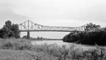
Horseshead Creek Bridge
The US 64 Horsehead Creek Bridge is a historic bridge, carrying US 64 across Horsehead Creek east of Hartman. Its two main spans are Parker pony trusses, 102 feet (31 m) in length, with steel deck girder approach spans giving the bridge a total length of 415 feet (126 m). The trusses are mounted on concrete piers, with the approaches on concrete piers and abutments. The bridge was built in 1933–1934 by Fred Luttjohann, and served as a major crossing point and transportation route until the construction of Interstate 40 (I-40) to the north.[21]
Scotia
The Old US 64, Scotia Segment is a section of historic roadway in the unincorporated community of Scotia. It extends eastward from Country Lane, south of the current alignment of US 64. It is about 0.5 miles (0.80 km) in length, following an arced route, and is covered in a bituminous that has in places deteriorated into gravel. It is believed to be the longest-surviving element of the c. 1920 alignment of US 64 in Arkansas, and was built on an alignment dating to the 1830s. It is believed this road formed part of the Trail of Tears.[22]
Menifee
Old U.S. Route 64 is a historic former alignment of US 64 in Menifee. Now a portion of Canal Road, it consists of a 0.5-mile (0.80 km) section of concrete pavement, extending southward from the current alignment of US 64 near the center of Menifee. Built in 1931 by the Zeigler Construction Company, it is the longest intact portion of the highway's original alignment in Conway County. It was bypassed by the present alignment in 1961.[23]
Historic segment gallery
 Van Buren segment looking east
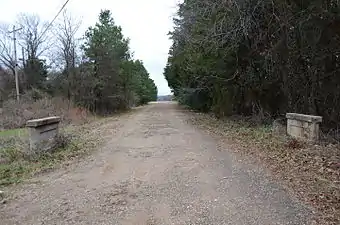 Altus segment
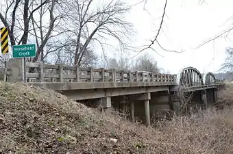 Horsehead Creek Bridge
 Scotia segment
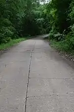 Menifee segment
Major intersections
| County | Location | mi[1] | km | Destinations | Notes | ||
|---|---|---|---|---|---|---|---|
| Arkansas River | 0.00 | 0.00 | Continuation into Oklahoma | ||||
| J. Fred Patton Garrison Avenue Bridge Arkansas–Oklahoma line | |||||||
| Sebastian | Fort Smith | 0.3 | 0.48 | ||||
| 0.7 | 1.1 | West end of US 71B overlap | |||||
| 4.8 | 7.7 | ||||||
| Arkansas River | 5.5 | 8.9 | Bridge | ||||
| Crawford | Van Buren | 5.9 | 9.5 | West end of AR 59 overlap | |||
| 6.3 | 10.1 | East end of AR 59 overlap | |||||
| 6.9 | 11.1 | ||||||
| 8.2 | 13.2 | I-540 exit 2 | |||||
| 8.8 | 14.2 | ||||||
| | 10.3 | 16.6 | |||||
| Alma | 14.0 | 22.5 | East end of US 71B overlap | ||||
| 15.3 | 24.6 | ||||||
| Mulberry | |||||||
| 24.8 | 39.9 | ||||||
| Franklin | | 28.5 | 45.9 | ||||
| Ozark | 36.5 | 58.7 | |||||
| 37.8 | 60.8 | West end of AR 23 overlap | |||||
| 38.5 | 62.0 | East end of AR 23 overlap | |||||
| 38.8 | 62.4 | ||||||
| Altus | 43.7 | 70.3 | |||||
| 44.0 | 70.8 | ||||||
| Johnson | Coal Hill | 51.2 | 82.4 | ||||
| Clarksville | 60.7 | 97.7 | |||||
| 61.6 | 99.1 | I-40 exit 55 | |||||
| 62.4 | 100.4 | ||||||
| 65.0 | 104.6 | West end of AR 103 overlap | |||||
| 65.4 | 105.3 | East end of AR 103 overlap | |||||
| 66.4 | 106.9 | ||||||
| Lamar | 67.9 | 109.3 | West end of AR 123 overlap | ||||
| 69.8 | 112.3 | East end of AR 123 overlap | |||||
| 70.1 | 112.8 | ||||||
| 72.0 | 115.9 | I-40 exit 64 | |||||
| Knoxville | 74.5 | 119.9 | |||||
| Piney | |||||||
| Pope | London | 82.3 | 132.4 | ||||
| 84.8 | 136.5 | ||||||
| I-40 exit 78 | |||||||
| Russellville | 87.6 | 141.0 | West end of AR 326 overlap | ||||
| 87.8 | 141.3 | East end of AR 326 overlap | |||||
| 90.6 | 145.8 | ||||||
| 91.4 | 147.1 | ||||||
| 92.2 | 148.4 | Former AR 326 | |||||
| 92.4 | 148.7 | West end of AR 331 overlap | |||||
| 92.9 | 149.5 | East end of AR 331 overlap | |||||
| 93.1 | 149.8 | ||||||
| Pottsville | 96.1 | 154.7 | |||||
| 96.9 | 155.9 | ||||||
| Atkins | 102.6 | 165.1 | |||||
| 102.7 | 165.3 | ||||||
| Conway | | ||||||
| | 109.2 | 175.7 | |||||
| Morrilton | 115.9 | 186.5 | |||||
| 116.2 | 187.0 | ||||||
| 117.4 | 188.9 | interchange | |||||
| Plumerville | 121.9 | 196.2 | |||||
| Menifee | 126.9 | 204.2 | |||||
| Faulkner | Conway | 130.5 | 210.0 | ||||
| 134.2 | 216.0 | ||||||
| 134.9 | 217.1 | ||||||
| 135.6 | 218.2 | West end of US 65B overlap | |||||
| 136.3 | 219.4 | Siebenmorgen Road (AR 266) / Markham Street | roundabout | ||||
| 136.8 | 220.2 | East end of US 65B overlap | |||||
| 137.6 | 221.4 | I-40 exit 127 | |||||
| Hamlet | 144.4 | 232.4 | |||||
| Funston | 150.6 | 242.4 | |||||
| | |||||||
| White | | 157.1 | 252.8 | ||||
| Beebe | 168.7 | 271.5 | interchange; West end of US 67 / US 167 overlap; US 64 west follows exit 28 | ||||
| see US 67 | |||||||
| Bald Knob | 196.1 | 315.6 | interchange; East end of US 67 / US 167 overlap; US 64 east follows exit 55 | ||||
| 196.4 | 316.1 | ||||||
| Woodruff | Augusta | 208.5 | 335.5 | ||||
| 208.8 | 336.0 | ||||||
| 209.6 | 337.3 | ||||||
| | 210.0 | 338.0 | |||||
| Patterson | 216.4 | 348.3 | West end of AR 17 overlap | ||||
| McCrory | 218.4 | 351.5 | East end of AR 17 overlap | ||||
| | 221.7 | 356.8 | |||||
| | 224.3 | 361.0 | West end of AR 269 overlap | ||||
| Morton | 224.8 | 361.8 | East end of AR 269 overlap | ||||
| Cross | Fair Oaks | West end of US 49 overlap | |||||
| East end of US 49 overlap | |||||||
| Central | 234.0 | 376.6 | |||||
| | 234.9 | 378.0 | |||||
| | 239.6 | 385.6 | |||||
| Wynne | 242.0 | 389.5 | West end of AR 1 overlap | ||||
| 242.6 | 390.4 | East end of AR 1 overlap | |||||
| | 246.1 | 396.1 | |||||
| Levesque | 246.7 | 397.0 | |||||
| 246.8 | 397.2 | ||||||
| | 254.9 | 410.2 | West end of AR 75 overlap | ||||
| Parkin | 256.1 | 412.2 | East end of AR 75 overlap | ||||
| 256.2 | 412.3 | ||||||
| 257.3 | 414.1 | ||||||
| Crittenden | | 259.7 | 417.9 | ||||
| Earle | 261.1 | 420.2 | |||||
| 261.4 | 420.7 | ||||||
| 262.4 | 422.3 | ||||||
| | 270.4 | 435.2 | |||||
| | 271.4 | 436.8 | |||||
| | 273.0 | 439.4 | |||||
| Marion | 277.6 | 446.8 | |||||
| 278.3 | 447.9 | West end of I-55 / US 61 / US 63 overlap; US 64 west follows exit 10 | |||||
| see I-55 | |||||||
| Mississippi River | 289.4 | 465.7 | Memphis & Arkansas Bridge Arkansas–Tennessee line | ||||
| Continuation into Tennessee | |||||||
| 1.000 mi = 1.609 km; 1.000 km = 0.621 mi | |||||||
See also
- List of bridges on the National Register of Historic Places in Arkansas
- National Register of Historic Places listings in Crawford County, Arkansas
- National Register of Historic Places listings in Conway County, Arkansas
- National Register of Historic Places listings in Franklin County, Arkansas
- National Register of Historic Places listings in Johnson County, Arkansas
- National Register of Historic Places listings in Pope County, Arkansas
- Special routes of U.S. Route 64, six special routes of US 64 exist in Arkansas
References
- 1 2 3 "[Arkansas] State Highways 2009 (Database)." April 2010. AHTD: Planning and Research Division. Database. Archived 2011-07-07 at the Wayback Machine Retrieved April 11, 2011.
- ↑ Map of Fort Smith, Sebastian County, Arkansas (Map) (January 2006 ed.). Arkansas State Highway and Transportation Department. Retrieved March 24, 2011.
- ↑ General Highway Map - Sebastian County, Arkansas (PDF) (Map) (5/10/10 ed.). Arkansas State Highway and Transportation Department. Retrieved March 24, 2011.
- ↑ General Highway Map - Crawford County, Arkansas (PDF) (Map) (5/10/10 ed.). Arkansas State Highway and Transportation Department. Retrieved March 24, 2011.
- ↑ General Highway Map - Franklin County, Arkansas (PDF) (Map) (1/3/11 ed.). Arkansas State Highway and Transportation Department. Retrieved March 24, 2011.
- ↑ Map of Clarksville, Johnson County, Arkansas (PDF) (Map) (May 2006 ed.). Arkansas State Highway and Transportation Department. Retrieved March 24, 2011.
- ↑ General Highway Map - Johnson County, Arkansas (PDF) (Map) (2/8/11 ed.). Arkansas State Highway and Transportation Department. Retrieved March 24, 2011.
- ↑ "Vilonia bypass to open Monday". Log Cabin Democrat. Retrieved 2019-03-11.
- ↑ "Mapping - Tourist Maps". www.arkansashighways.com. Retrieved 2019-03-11.
- ↑ "Bargains Galore on 64". Archived from the original on 2011-05-12. Retrieved 2011-04-12.
- ↑ Christ, Mark K. (June 5, 2015). "Memphis to Little Rock Road". Encyclopedia of Arkansas History & Culture. Little Rock: Butler Center for Arkansas Studies at the Central Arkansas Library System. Retrieved December 21, 2019.
- ↑ "National Register Information System – Old US 64, Menifee Segment (#06000071)". National Register of Historic Places. National Park Service. November 2, 2013. Retrieved December 21, 2019.
- ↑ "National Register Information System – Old US 64, Scotia Segment (#07000959)". National Register of Historic Places. National Park Service. November 2, 2013. Retrieved December 21, 2019.
- ↑ "National Register Information System – Old U.S. 64-Van Buren Segment (#09001242)". National Register of Historic Places. National Park Service. November 2, 2013. Retrieved December 21, 2019.
- ↑ "National Register Information System – Johnson County Line-Ozark-Crawford County Line Road, Altus Segment (#10000033)". National Register of Historic Places. National Park Service. November 2, 2013. Retrieved December 21, 2019.
- ↑ "National Register Information System – U.S. 64 Horsehead Creek Bridge (#14000792)". National Register of Historic Places. National Park Service. November 2, 2013. Retrieved December 21, 2019.
- ↑ "National Register Information System – Arkansas Highway History and Architecture Multiple Property Submission (#64500014)". National Register of Historic Places. National Park Service. November 2, 2013. Retrieved December 21, 2019.
- ↑ "National Register Information System – Historic Bridges of Arkansas Multiple Property Submission (#64500021)". National Register of Historic Places. National Park Service. November 2, 2013. Retrieved December 21, 2019.
- ↑ "NRHP nomination for Old US 64-Van Buren Segment" (PDF). Arkansas Preservation. Retrieved April 23, 2015.
- ↑ "NRHP nomination for Johnson County Line-Ozark-Crawford County Line Road, Altus Segment" (PDF). Arkansas Preservation. Retrieved December 21, 2019.
- ↑ "NRHP nomination for US 64 Horsehead Creek Bridge" (PDF). Arkansas Preservation. Retrieved May 26, 2016.
- ↑ "NRHP nomination for Old US 64, Scotia Segment" (PDF). Arkansas Preservation. Retrieved May 2, 2016.
- ↑ "NRHP nomination for Old US 64, Menifee Segment" (PDF). Arkansas Preservation. Retrieved April 12, 2016.
| Topics | |
|---|---|
| Lists by state |
|
| Lists by insular areas | |
| Lists by associated state | |
| Other areas | |
| Related | |