Montmelon | |
|---|---|
 Coat of arms | |
Location of Montmelon | |
 Montmelon  Montmelon | |
| Coordinates: 47°21′N 07°11′E / 47.350°N 7.183°E | |
| Country | Switzerland |
| Canton | Jura |
| District | Porrentruy |
| Area | |
| • Total | 1,197 km2 (462 sq mi) |
| Elevation | 594 m (1,949 ft) |
| Population (2003) | |
| • Total | 114 |
| • Density | 0.095/km2 (0.25/sq mi) |
| Time zone | UTC+01:00 (Central European Time) |
| • Summer (DST) | UTC+02:00 (Central European Summer Time) |
| Postal code(s) | 2883 |
| SFOS number | 827 |
| Localities | Montmelon-Dessus, Montmelon-Dessous, Ravines |
| Surrounded by | Asuel, Saint-Ursanne, Montenol, Epauvillers, Saint-Brais, Glovelier, Boécourt, Cornol, Courgenay, Seleute, Ocourt |
| Website | SFSO statistics |
Montmelon is a village and former municipality in the district of Porrentruy in the canton of Jura in Switzerland.
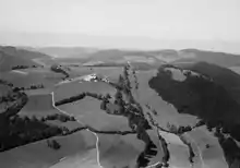
Aerial view (1957)
Since January 1, 2009 it is a part of the new municipality Clos du Doubs.
References
The municipality was composed of several villages (Montmelon-Dessus, Montmelon-dessous, Ravines) and of many dispersed farms. The municipality had approximately 100 inhabitants, many of whom are farmers.
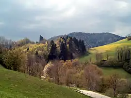
Montmelon, Doubs, Jura in spring.
Wikimedia Commons has media related to Montmelon.
This article is issued from Wikipedia. The text is licensed under Creative Commons - Attribution - Sharealike. Additional terms may apply for the media files.