U.S. Highway 82 | ||||
|---|---|---|---|---|
US 82 highlighted in red | ||||
| Route information | ||||
| Maintained by TxDOT | ||||
| Length | 564.900 mi[1] (909.118 km) | |||
| Existed | 1935–present | |||
| Major junctions | ||||
| West end | ||||
| ||||
| East end | ||||
| Location | ||||
| Country | United States | |||
| State | Texas | |||
| Counties | Yoakum, Terry, Hockley, Lubbock, Crosby, Dickens, King, Knox, Baylor, Archer, Wichita, Clay, Montague, Cooke, Grayson, Fannin, Lamar, Red River, Bowie | |||
| Highway system | ||||
| ||||

In the U.S. state of Texas, U.S. Route 82 (US 82) is a U.S. Highway that runs east from the New Mexico state line through West Texas and Lubbock to the Arkansas state line at Texarkana.
Route description
New Mexico to Wichita Falls
US 82 crosses into Texas from New Mexico at Texas Farm to Market Road 769, turning northeastward toward Plains, where it merges with US 380. US 82 is co-signed with US 380 from Plains to Brownfield, where it joins US 62, and US 380 leaves the route. US 82/62 continues northeastward toward Lubbock.
In Lubbock, US 82 and US 62 split, where US 82 has been upgraded to a full access freeway, named the Marsha Sharp Freeway, in honor of retired Texas Tech Lady Raiders basketball coach Marsha Sharp. On the east side of the city, US 82 travels as a surface street along Parkway Drive and it once again merges with US 62 (along with State Highway 114) where it continues eastward through Ralls, where US 62 makes a sharp turn to the north and leaves the route. US 82 continues eastward across the level plains of the Llano Estacado to Crosbyton and then dips downward as it crosses the White River of Blanco Canyon, where the Texas Department of Transportation maintains the Silver Falls Rest Area with facilities and hiking trails. After climbing out of Blanco Canyon, US 82 eventually exits the Llano Estacado and enters the rolling plains near Dickens.
US 82/SH 114 continues eastward as a co-signed route until Seymour, where it merges with U.S. Highways 183, 277 and 283, with US 183 and 283 leaving the route at Mabelle. US 82/277 continues eastward to Wichita Falls, merging with I-44 and US 287 just south of downtown at Mile marker 0.
Wichita Falls to Arkansas
US 82 leaves US 287 at Henrietta and continues east towards the small towns of Nocona (beginning as a four-lane divided highway), St. Jo and Muenster and crossing I-35 in Gainesville at a partial cloverleaf interchange (It has since been converted to a frontage road interchange in 2012.). The highway continues east towards Whitesboro and Sherman where it crosses US Highway 75 at a three-level diamond interchange (the portion through Sherman is called the Buck Owens Freeway in honor of the country music star, who was born in Sherman). Prior to the 1990s, the two highways ran concurrently on the route of SH 56 before being rerouted northeast of Sherman on its present-day route. The highway continues east to Bells where US 82 cross US Route 69.
In Bonham, Texas, US 82 crosses SH 121 while the route runs parallel with SH 56 until Honey Grove where SH 56 ends. US 82 enters Paris at a diamond interchange where it runs concurrent with Loop 286 on the north side of the city as a Business Route runs through the center of the city before rejoining on the east side of Paris. At a diamond interchange on the north side of Paris, US 82/TX Loop 286 meets with US 271 where both highways run concurrent on the northeast side of town before US 82 branches off at another diamond interchange on the east side of Paris. After passing around Clarksville and other smaller towns the highway is crossed by Interstate 30 east of New Boston at a partial cloverleaf and continues to run parallel to IH 30 into Arkansas through downtown Texarkana.[2]
History
US 82 was first designated in Texas in 1939, traveling from Lubbock to Texarkana. The highway was extended from Lubbock to the New Mexico state line in 1963. Between 1974 and 1994, US 82 was re-routed from Whitesboro to Honey Grove; the old routing became SH 56.[3] The highway was re-routed from Allendale Road to US 281/US 287 through Wichita Falls in 1998 with a bypass built around Holliday in 2005. US 82 was re-routed around Clarkesville in 2006, creating a concurrency with SH 37. The highway was re-routed south of Guthrie in 2007, with part of the former route becoming Spur 729.[4]
Marsha Sharp Freeway
The Marsha Sharp Freeway, named for former Texas Tech Lady Raiders basketball coach Marsha Sharp, was built along US 82 in Lubbock, with construction officially beginning in May 2003, with development going back to the 1980s.[5][6] In 1998, funding was first received. The five-phase project was scheduled to be completed in 2015.
Phase 2 of the project was scheduled to be completed in December 2008 at a cost of $140 million. It involved construction of the freeway from Salem Avenue to Avenue L and erecting interchanges at 19th Street, Quaker Avenue, Fourth Street, and Avenue Q in Lubbock. Currently construction on the freeway has started from Milwaukee Ave. to Upland Ave. and on the intersection of Spur 327 and U.S. 62/82.[7]
The section of freeway between West Loop 289 and Avenue L was widened from four lanes to six lanes between March 6, 2017 and March 5, 2018, officially marking the end of the freeway's construction.[8][9]
Future
TxDOT began upgrading U.S. 82 in Grayson and Fannin County in 2013. The four-lane divided highway upgrade between Sherman and Bonham was completed in 2015. TxDOT plans to continue this upgrade to the Fannin and Lamar County line by 2020. Long term planning calls for U.S. 82 to be a four-lane divided highway system the entire length between Wichita Falls and Texarkana as a potential alternate route through north Texas in order to bypass the overcrowded Dallas/Fort Worth Metroplex.
It is being upgraded to a 4 lane divided highway west of Nocona, and a partial bypass is planned to run south of Gainesville.
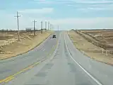 US 82 Outside of Henrietta, TX
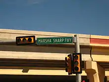 The Marsha Sharp Freeway on U.S. Highway 82 in Lubbock
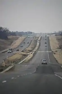 Heading west on US-82 out of Sherman, TX
Major intersections
| County | Location | mi | km | Exit | Destinations | Notes | |
|---|---|---|---|---|---|---|---|
| Texas–New Mexico line | 0.00 | 0.00 | Continuation into New Mexico | ||||
| Yoakum | | 0.1 | 0.16 | ||||
| | 11.6 | 18.7 | |||||
| Plains | 14.9 | 24.0 | West end of US 380 overlap | ||||
| 15.9 | 25.6 | ||||||
| | 19.9 | 32.0 | |||||
| | 27.9 | 44.9 | |||||
| Terry | | 36.5 | 58.7 | ||||
| Gomez | 41.4 | 66.6 | |||||
| Brownfield | 46.5 | 74.8 | |||||
| 47.4 | 76.3 | West end of US 62 / US 385 overlap | |||||
| 47.5 | 76.4 | East end of US 380 overlap | |||||
| 48.4 | 77.9 | East end of US 385 overlap | |||||
| 48.5 | 78.1 | ||||||
| | 52.1 | 83.8 | |||||
| Meadow | 58.6 | 94.3 | |||||
| Hockley | Ropesville | 65.3 | 105.1 | ||||
| Lubbock | | 72.3 | 116.4 | West end of FM 1585 overlap | |||
| | 74.0 | 119.1 | East end of FM 1585 overlap; future Loop 88 | ||||
| Wolfforth | 74.8 | 120.4 | Interchange; west end of freeway | ||||
| 75.4 | 121.3 | ||||||
| 76.9 | 123.8 | ||||||
| Lubbock | 78.9 | 127.0 | Upland Avenue | ||||
| 79.7 | 128.3 | Eastbound exit and westbound entrance | |||||
| 79.9 | 128.6 | Milwaukee Avenue | |||||
| 81.0 | 130.4 | ||||||
| 82.1 | 132.1 | 34th Street / Slide Road | |||||
| 83.6 | 134.5 | Quaker Avenue | |||||
| 84.0 | 135.2 | East end of US 62 overlap; no direct exits to SH 114 west (EB signed at Quaker Avenue; WB signed at Texas Tech Parkway); access to Covenant Hospital and University Medical Center | |||||
| 84.5 | 136.0 | Access to University Medical Center | |||||
| 86.4 | 139.0 | Westbound exit and eastbound entrance | |||||
| 85.6 | 137.8 | University Avenue – Texas Tech University | |||||
| 86.5 | 139.2 | ||||||
| 87.3 | 140.5 | Avenue L / Texas Avenue / Buddy Holly Avenue | no direct westbound exit (signed at I-27) | ||||
| 88.0 | 141.6 | Interchange; east end of freeway; I-27 exit 4 | |||||
| 90.7 | 146.0 | Interchange; no westbound entrance; west end of US 62 / SH 114 overlap | |||||
| 90.9 | 146.3 | Interchange | |||||
| | 94.6 | 152.2 | |||||
| | 95.9 | 154.3 | west end of FM 1729 overlap | ||||
| | 97.0 | 156.1 | east end of FM 1729 overlap | ||||
| | 100.0 | 160.9 | |||||
| | 103.1 | 165.9 | west end of FM 789 overlap | ||||
| | 104.1 | 167.5 | east end of FM 789 overlap | ||||
| Crosby | Lorenzo | 107.6 | 173.2 | west end of FM 378 overlap | |||
| 108.1 | 174.0 | east end of FM 378 overlap | |||||
| | 111.4 | 179.3 | |||||
| | 113.4 | 182.5 | |||||
| | 115.5 | 185.9 | east end of US 62 overlap | ||||
| Ralls | 116.1 | 186.8 | |||||
| | 118.8 | 191.2 | |||||
| Crosbyton | 124.9 | 201.0 | |||||
| | 128.6 | 207.0 | |||||
| | 133.2 | 214.4 | |||||
| | 135.2 | 217.6 | |||||
| Dickens | | 138.5 | 222.9 | ||||
| | 148.4 | 238.8 | |||||
| Dickens | 149.2 | 240.1 | |||||
| 149.6 | 240.8 | ||||||
| | 154.1 | 248.0 | |||||
| | 161.0 | 259.1 | |||||
| King | | 180.9 | 291.1 | Interchange | |||
| | 195.0 | 313.8 | |||||
| Knox | Benjamin | 212.6 | 342.1 | ||||
| | 219.9 | 353.9 | west end of FM 267 overlap | ||||
| | 220.1 | 354.2 | east end of FM 267 overlap | ||||
| | 230.3 | 370.6 | |||||
| Baylor | Red Springs | 235.3 | 378.7 | ||||
| | 239.3 | 385.1 | |||||
| Seymour | 244.2 | 393.0 | East end of SH 114 overlap; west end of US 183 Bus. overlap | ||||
| 245.1 | 394.5 | RM Spur 1919 | |||||
| | 245.3 | 394.8 | |||||
| | 246.3 | 396.4 | interchange; east end of US 183 Bus. overlap; west end of US 183 / US 277 / US 283 overlap | ||||
| See US 277 | |||||||
| Wichita | Wichita Falls | 294.4 | 473.8 | East end of US 277 overlap; west end of US 281 / US 287 overlap | |||
| See US 287 | |||||||
| Clay | Henrietta | 311.7 | 501.6 | Interchange; east end of US 287 overlap | |||
| 313.0 | 503.7 | West end of SH 148 overlap | |||||
| 313.4 | 504.4 | East end of SH 148 overlap | |||||
| 313.5 | 504.5 | ||||||
| 314.0 | 505.3 | ||||||
| | 323.6 | 520.8 | |||||
| | 325.6 | 524.0 | |||||
| Montague | Ringgold | 328.1 | 528.0 | ||||
| 328.3 | 528.3 | Interchange | |||||
| Belcherville | 334.7 | 538.6 | |||||
| Nocona | 340.9 | 548.6 | |||||
| 341.0 | 548.8 | ||||||
| | 348.7 | 561.2 | |||||
| Saint Jo | 353.9 | 569.5 | |||||
| 354.6 | 570.7 | ||||||
| 354.8 | 571.0 | ||||||
| Cooke | Muenster | 363.7 | 585.3 | ||||
| | 366.3 | 589.5 | |||||
| Myra | 367.4 | 591.3 | |||||
| Lindsay | 372.4 | 599.3 | west end of FM 1199 overlap | ||||
| 372.5 | 599.5 | east end of FM 1199 overlap | |||||
| 372.9 | 600.1 | ||||||
| Gainesville | 375.0 | 603.5 | |||||
| 376.4 | 605.8 | I-35 exit 498 | |||||
| 376.9 | 606.6 | Dixon Street | Interchange; eastbound exit and westbound entrance | ||||
| 377.6 | 607.7 | Interchange | |||||
| 379.3 | 610.4 | ||||||
| 380.7 | 612.7 | ||||||
| Oak Ridge | 384.9 | 619.4 | Interchange | ||||
| Grayson | Whitesboro | 388.8 | 625.7 | 622 | Interchange | ||
| 390.9 | 629.1 | 624 | Interchange | ||||
| Sadler | 394.3 | 634.6 | 628 | Interchange | |||
| Sherman | 403.0 | 648.6 | 636 | Interchange | |||
| 406.0 | 653.4 | 640 | interchange; west end of freeway | ||||
| 407.5 | 655.8 | 641 | no direct westbound exit (signed at exit 642A) | ||||
| 407.9 | 656.5 | 642A | Signed as exit 642 eastbound; US 75 exit 63 | ||||
| 408.5 | 657.4 | 642B | Loy Lake Road | no direct eastbound exit (signed at exit 642) | |||
| 409.0 | 658.2 | 643 | |||||
| 409.9 | 659.7 | 644 | Skaggs Road | No direct westbound exit (signed at exit 645) | |||
| 410.9 | 661.3 | 645 | interchange; east end of freeway | ||||
| Bells | 419.2 | 674.6 | 653 | Interchange | |||
| 420.1 | 676.1 | 654 | Interchange | ||||
| Fannin | Savoy | 423.1 | 680.9 | 658 | Interchange | ||
| Ector | 428.1 | 689.0 | |||||
| | 430.6 | 693.0 | |||||
| Bonham | 432.8 | 696.5 | 670 | interchange | |||
| 433.7 | 698.0 | 671 | interchange | ||||
| Lannius | 440.8 | 709.4 | |||||
| | 443.6 | 713.9 | |||||
| Honey Grove | 447.8 | 720.7 | |||||
| 449.2 | 722.9 | 686 | Interchange | ||||
| 452.0 | 727.4 | ||||||
| Lamar | Petty | 454.5 | 731.4 | ||||
| 455.1 | 732.4 | ||||||
| 455.4 | 732.9 | ||||||
| Brookston–Toco line | 462.6 | 744.5 | |||||
| Paris | 467.1 | 751.7 | |||||
| 468.5 | 754.0 | Interchange; west end of Loop 286 overlap | |||||
| 470.4 | 757.0 | Interchange | |||||
| 471.8 | 759.3 | Interchange; west end of US 271 overlap | |||||
| 472.3 | 760.1 | Interchange, access to Paris Regional Medical Center | |||||
| 473.2 | 761.5 | ||||||
| 473.5 | 762.0 | Interchange | |||||
| 474.7 | 764.0 | Pine Mill Road | Interchange | ||||
| 475.1 | 764.6 | Interchange; east end of US 271/Loop 286 overlap | |||||
| Reno | 478.1 | 769.4 | |||||
| Sun Valley | 479.7 | 772.0 | |||||
| Blossom | 482.5 | 776.5 | West end of FM 196 overlap | ||||
| 482.8 | 777.0 | East end of FM 196 overlap | |||||
| 483.9 | 778.8 | ||||||
| Red River | Detroit | 489.6 | 787.9 | ||||
| 490.4 | 789.2 | ||||||
| | 498.0 | 801.5 | |||||
| Clarksville | 500.3 | 805.2 | |||||
| 501.7 | 807.4 | West end of SH 37 overlap | |||||
| 503.2 | 809.8 | Interchange; east end of SH 37 overlap | |||||
| 504.6 | 812.1 | ||||||
| 504.9 | 812.6 | ||||||
| | 505.2 | 813.0 | |||||
| | 505.6 | 813.7 | |||||
| Annona | 511.5 | 823.2 | West end of FM 44 overlap | ||||
| 511.6 | 823.3 | East end of FM 44 overlap | |||||
| | 517.7 | 833.2 | |||||
| Avery | 519.7 | 836.4 | West end of FM 911 overlap | ||||
| 519.9 | 836.7 | East end of FM 911 overlap | |||||
| 520.4 | 837.5 | ||||||
| Bowie | Oak Grove | 525.7 | 846.0 | ||||
| De Kalb | 528.9 | 851.2 | Interchange | ||||
| 530.1 | 853.1 | ||||||
| 530.3 | 853.4 | ||||||
| 530.8 | 854.2 | ||||||
| Malta | 536.0 | 862.6 | |||||
| | 539.2 | 867.8 | |||||
| | 539.9 | 868.9 | I-30 exit 199 | ||||
| New Boston | 542.0 | 872.3 | |||||
| 543.0 | 873.9 | Interchange | |||||
| | 547.2 | 880.6 | |||||
| Hooks | 548.5 | 882.7 | |||||
| 549.9 | 885.0 | ||||||
| 551.6 | 887.7 | ||||||
| Leary | 552.9 | 889.8 | |||||
| 554.2 | 891.9 | ||||||
| 554.9 | 893.0 | ||||||
| | 556.8 | 896.1 | |||||
| | 557.6 | 897.4 | |||||
| Nash | 559.3 | 900.1 | |||||
| Texarkana | 561.2 | 903.2 | I-369 exit 114A northbound, 114 southbound | ||||
| 563.3 | 906.5 | ||||||
| 563.9 | 907.5 | ||||||
| 564.5 | 908.5 | West end of US 67 overlap | |||||
| 564.9 | 909.1 | Arkansas state line; east end of US 71 overlap | |||||
1.000 mi = 1.609 km; 1.000 km = 0.621 mi
| |||||||
References
- ↑ Transportation Planning and Programming Division (n.d.). "U.S. Highway No. 82". Highway Designation Files. Texas Department of Transportation. Retrieved March 5, 2008.
- ↑ Google (March 5, 2008). "overview map of US 82" (Map). Google Maps. Google. Retrieved March 5, 2008.
- ↑ Transportation Planning and Programming Division (n.d.). "State Highway No. 56". Highway Designation Files. Texas Department of Transportation. Retrieved May 9, 2018.
- ↑ Transportation Planning and Programming Division (n.d.). "State Highway Spur No. 729". Highway Designation Files. Texas Department of Transportation. Retrieved May 9, 2018.
- ↑ "Lubbock leaders turn dirt for freeway project" (PDF). Freeway Today. TxDOT. May 2003. Retrieved May 9, 2018.
- ↑ "Marsha Sharp Freeway". TxDOT. Retrieved May 9, 2018.
- ↑ "Marsha Sharp freeway construction could complicate campus traffic until 2008". The Daily Toreador. April 13, 2007.
- ↑ "TxDOT begins project to widen Marsha Sharp Freeway". KCBD. March 6, 2017. Retrieved May 9, 2018.
- ↑ "Construction Complete On Marsha Sharp Freeway". KAMC. March 5, 2018. Retrieved May 9, 2018.