Marjeyoun District | |
|---|---|
District | |
 Khiam, Marjeyoun District | |
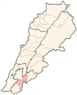 Location in Lebanon | |
| Coordinates: 33°21′43″N 35°35′23″E / 33.36194°N 35.58972°E | |
| Country | |
| Governorate | Nabatiyeh Governorate |
| Capital | Marjeyoun |
| Area | |
| • Total | 102.4 sq mi (265.3 km2) |
| Elevation | 2,820 ft (860 m) |
| Population (2017) | |
| • Total | 85,960 |
| • Density | 840/sq mi (320/km2) |
| Ministry of Public Health, Lebanese Republic | |
| Time zone | UTC+2 (EET) |
| • Summer (DST) | UTC+3 (EEST) |
.jpg.webp)
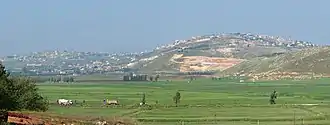
Qlayaa, Marjeyoun District
The Marjeyoun District is a district in the Nabatieh Governorate of Lebanon. The capital of the district is Marjeyoun.
Marjeyoun stands at a hill facing Mount Hermon to the East, with Beaufort castle. The Litani River and Mount Amel are to the West, The Rihan, Niha and the Lebanon Mountain Range to the North and the fertile plains of Sahil Marjeyoun that extends into Northern Israel between the Galilee finger and plains immediately underneath the Golan Heights.
Photos of Marjeyoun
References
- ↑ UN Records
External links
| Akkar Governorate | ||
|---|---|---|
| Baalbek-Hermel Governorate | ||
| Beirut Governorate | ||
| Mount Lebanon Governorate | ||
| North Governorate | ||
| Beqaa Governorate | ||
| South Governorate | ||
| Nabatieh Governorate | ||
| Capital | | |
|---|---|---|
| Towns and villages | ||
| Other | ||
This article is issued from Wikipedia. The text is licensed under Creative Commons - Attribution - Sharealike. Additional terms may apply for the media files.