Songrim
송림시 | |
|---|---|
| Korean transcription(s) | |
| • Chosŏn'gŭl | 송림시 |
| • Hancha | 松林市 |
| • McCune-Reischauer | Songrim-si |
| • Revised Romanization | Songrim-si |
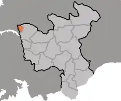 Map of North Hwanghae showing the location of Songrim | |
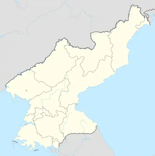 Songrim Location within North Korea | |
| Coordinates: 38°45′15″N 125°38′42″E / 38.7542°N 125.645°E | |
| Country | North Korea |
| Province | North Hwanghae Province |
| Administrative divisions | 19 tong, 6 ri |
| Population (2008) | |
| • Total | 128,831 |
| • Dialect | Hwanghae |
| Time zone | UTC+9 (Pyongyang Time) |
Songrim (Korean pronunciation: [soŋ.ɾim]) is a city on the Taedong River in North Hwanghae Province, North Korea. It had a population of 128,831 in 2008.
Administrative divisions
Songrim is divided into 19 tong (neighbourhoods) and 6 ri (villages):
- Chŏn-dong
- Ch'ŏlsan-dong
- Kkotp'in-dong
- Negil-dong
- Oryu-dong
- Saemaŭl-dong
- Saesallim 1-dong
- Saesallim 2-dong
- Saesallim 3-dong
- Saesallim 4-dong
- Samga-dong
- Sap'o 1-dong
- Sap'o 2-dong
- Sinhŭng-dong
- Sŏkt'ap-tong
- Songsan-dong
- Tongsong-dong
- Un'gok-tong
- Wŏlbong-dong
- Masal-li
- Sillyang-ri
- Sinsŏng-ri
- Sŏkt'al-li
- Sŏsong-ri
- Tangsal-li
History
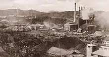
Mitsubishi iron works during the colonial period
The city was originally named Solme. Iron works began to be developed during the Japanese colonial period of Korea. Before Korean independence Songrim was known as Kyŏmip'o (Korean: 겸이포; Hanja: 兼二浦).
It was bombed during the Korean War, later it was rebuilt.
Climate
Songrim has a humid continental climate (Köppen climate classification: Dwa).
| Climate data for Songrim | |||||||||||||
|---|---|---|---|---|---|---|---|---|---|---|---|---|---|
| Month | Jan | Feb | Mar | Apr | May | Jun | Jul | Aug | Sep | Oct | Nov | Dec | Year |
| Mean daily maximum °C (°F) | −0.5 (31.1) |
1.7 (35.1) |
7.6 (45.7) |
15.7 (60.3) |
21.6 (70.9) |
25.9 (78.6) |
28.2 (82.8) |
28.4 (83.1) |
24.4 (75.9) |
18.3 (64.9) |
9.6 (49.3) |
1.4 (34.5) |
15.2 (59.4) |
| Daily mean °C (°F) | −5.5 (22.1) |
−3.4 (25.9) |
2.7 (36.9) |
9.9 (49.8) |
15.9 (60.6) |
20.7 (69.3) |
24.2 (75.6) |
24.2 (75.6) |
19.5 (67.1) |
12.5 (54.5) |
4.6 (40.3) |
−3.0 (26.6) |
10.2 (50.4) |
| Mean daily minimum °C (°F) | −10.4 (13.3) |
−8.4 (16.9) |
−2.2 (28.0) |
4.2 (39.6) |
10.3 (50.5) |
15.6 (60.1) |
20.3 (68.5) |
20.0 (68.0) |
14.6 (58.3) |
6.7 (44.1) |
−0.4 (31.3) |
−7.3 (18.9) |
5.3 (41.5) |
| Average precipitation mm (inches) | 12 (0.5) |
15 (0.6) |
25 (1.0) |
37 (1.5) |
79 (3.1) |
101 (4.0) |
292 (11.5) |
190 (7.5) |
102 (4.0) |
38 (1.5) |
39 (1.5) |
17 (0.7) |
947 (37.4) |
| Source: Climate-Data.org[1] | |||||||||||||
References
- ↑ "Climate: Songrim". Retrieved July 28, 2018.
Further reading
- Dormels, Rainer. North Korea's Cities: Industrial facilities, internal structures and typification. Jimoondang, 2014. ISBN 978-89-6297-167-5
External links
- City profile of Songrim Archived 2016-03-10 at the Wayback Machine

This article is issued from Wikipedia. The text is licensed under Creative Commons - Attribution - Sharealike. Additional terms may apply for the media files.