| Hounds Tooth, The Bugaboos | |
|---|---|
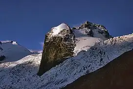 Hound's Tooth centered | |
| Highest point | |
| Elevation | 2,824 m (9,265 ft)[1] |
| Prominence | 19 m (62 ft)[1] |
| Coordinates | 50°43′27″N 116°46′30″W / 50.72417°N 116.77500°W[1] |
| Geography | |
| Country | Canada |
| Province | British Columbia |
| District | Kootenay Land District |
| Protected area | Bugaboo Provincial Park |
| Parent range | Purcell Mountains The Bugaboos |
| Topo map | NTS 82K10 Howser Creek |
| Geology | |
| Mountain type | Granite |
| Climbing | |
| First ascent | 1930 Conrad Kain[2] |
Hound's Tooth is a peak in the Purcell Mountains of the Columbia Mountains in southeastern British Columbia, Canada. Hound's Tooth is a rock pinnacle at the end of Marmolata Mountain's northeast ridge. Both mountains are Nunataks, sticking up from the middle of the Bugaboo Glacier.[1] The Hounds' Tooth is composed of a coarse, fractured granite.[2]
Climate
Based on the Köppen climate classification, Hound's Tooth is located in a subarctic climate zone with cold, snowy winters, and mild summers.[3] Winter temperatures can drop below −20 °C with wind chill factors below −30 °C.
See also
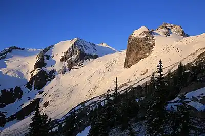
Hound's Tooth is large exposed rock face to right, north aspect
(Anniversary Peak to left)
(Anniversary Peak to left)
References
This article is issued from Wikipedia. The text is licensed under Creative Commons - Attribution - Sharealike. Additional terms may apply for the media files.