Hamadan County
Persian: شهرستان همدان | |
|---|---|
County | |
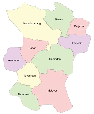 Location of Hamadan County in Hamadan province | |
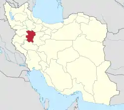 Location of Hamadan province in Iran | |
| Coordinates: 34°50′N 48°46′E / 34.833°N 48.767°E[1] | |
| Country | |
| Province | Hamadan |
| Capital | Hamadan |
| Districts | Central, Shara |
| Population (2016)[2] | |
| • Total | 676,105 |
| Time zone | UTC+3:30 (IRST) |
| Hamadan County can be found at GEOnet Names Server, at this link, by opening the Advanced Search box, entering "9207370" in the "Unique Feature Id" form, and clicking on "Search Database". | |
Hamadan County (Persian: شهرستان همدان) is in Hamadan province, Iran. Its capital is the city of Hamadan.
At the 2006 census, the county's population was 626,183 in 165,753 households.[3] The following census in 2011 counted 651,821 people in 190,808 households,[4] by which time Famenin District had been separated from the county in the establishment of Famenin County.[5] At the 2016 census, the county's population was 676,105 in 210,775 households.[2]
Administrative divisions
The population history and structural changes of Hamadan County's administrative divisions over three consecutive censuses are shown in the following table. The latest census shows two districts, nine rural districts, and four cities.[2]
| Administrative Divisions | 2006[3] | 2011[4] | 2016[2] |
|---|---|---|---|
| Central District | 560,133 | 628,626 | 655,859 |
| Abaru RD | 6,329 | 6,819 | 6,701 |
| Alvandkuh-e Gharbi RD | 17,276 | 19,499 | 18,454 |
| Alvandkuh-e Sharqi RD | 6,448 | 5,885 | 5,748 |
| Gonbad RD | 3,916 | 3,233 | 2,991 |
| Hegmataneh RD | 22,813 | 34,889 | 35,653 |
| Sangestan RD | 11,909 | 13,038 | 11,824 |
| Hamadan (city) | 473,149 | 525,794 | 554,406 |
| Juraqan (city) | 8,851 | 9,262 | 9,234 |
| Maryanaj (city) | 9,442 | 10,207 | 10,848 |
| Famenin District1 | 40,541 | ||
| Khorram Dasht RD | 14,050 | ||
| Mofatteh RD | 8,145 | ||
| Pish Khowr RD | 4,327 | ||
| Famenin (city) | 14,019 | ||
| Shara District | 25,509 | 23,195 | 20,242 |
| Chah Dasht RD | 6,708 | 5,411 | 4,407 |
| Jeyhun Dasht RD | 8,719 | 7,651 | 6,918 |
| Shur Dasht RD | 7,675 | 7,018 | 5,947 |
| Qahavand (city) | 2,407 | 3,115 | 2,970 |
| Total | 626,183 | 651,821 | 676,105 |
| RD: Rural District 1Became a part of Famenin County[5] | |||
Wikimedia Commons has media related to Hamadan County.
References
- ↑ OpenStreetMap contributors (16 October 2023). "Hamadan County" (Map). OpenStreetMap. Retrieved 16 October 2023.
- 1 2 3 4 "Census of the Islamic Republic of Iran, 1395 (2016)". AMAR (in Persian). The Statistical Center of Iran. p. 13. Archived from the original (Excel) on 21 April 2021. Retrieved 19 December 2022.
- 1 2 "Census of the Islamic Republic of Iran, 1385 (2006)". AMAR (in Persian). The Statistical Center of Iran. p. 13. Archived from the original (Excel) on 20 September 2011. Retrieved 25 September 2022.
- 1 2 "Census of the Islamic Republic of Iran, 1390 (2011)" (Excel). Iran Data Portal (in Persian). The Statistical Center of Iran. p. 13. Retrieved 19 December 2022.
- 1 2 Davoudi, Parviz (14 July 2009). "According to the proposal of the Ministry of Interior, the Board of Ministers agreed to the creation of Famenin and Abbasabad Counties in Hamadan and Mazandaran provinces". DOLAT (in Persian). Ministry of Interior, Cabinet of Ministers. Retrieved 15 November 2023.
Hamadan Province, Iran | |||||||||||||||||||||
|---|---|---|---|---|---|---|---|---|---|---|---|---|---|---|---|---|---|---|---|---|---|
| Capital |  | ||||||||||||||||||||
| Counties and cities |
| ||||||||||||||||||||
| Sights |
| ||||||||||||||||||||
| populated places | |||||||||||||||||||||
| Capital | |||||||||||||||||||||||||||||||
|---|---|---|---|---|---|---|---|---|---|---|---|---|---|---|---|---|---|---|---|---|---|---|---|---|---|---|---|---|---|---|---|
| Districts |
| ||||||||||||||||||||||||||||||
This article is issued from Wikipedia. The text is licensed under Creative Commons - Attribution - Sharealike. Additional terms may apply for the media files.