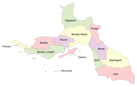
Hajjiabad County
Persian: شهرستان حاجیآباد | |
|---|---|
County | |
 Location of Hajjiabad County in Hormozgan province (top, green) | |
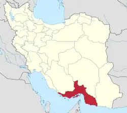 Location of Hormozgan province in Iran | |
| Coordinates: 28°12′00″N 56°08′14″E / 28.20000°N 56.13722°E[1] | |
| Country | |
| Province | Hormozgan |
| Capital | Hajjiabad |
| Districts | Central, Ahmadi, Fareghan |
| Population (2016)[2] | |
| • Total | 69,625 |
| Time zone | UTC+3:30 (IRST) |
Hajjiabad County (Persian: شهرستان حاجیآباد) is in Hormozgan province, Iran. Its capital is the city of Hajjiabad, located about 100 km north of Bandar Abbas (the capital of the province) and best known for its citrus produce.[3]
At the 2006 census, the county's population was 62,442 in 15,056 households.[4] The following census in 2011 counted 65,889 people in 17,580 households.[5] At the 2016 census, the county's population was 69,625 in 20,700 households.[2]
Administrative divisions
The population history and structural changes of Hajjiabad County's administrative divisions over three consecutive censuses are shown in the following table. The latest census shows three districts, six rural districts, and three cities.[2]
| Administrative Divisions | 2006[4] | 2011[5] | 2016[2] |
|---|---|---|---|
| Central District | 38,610 | 39,955 | 45,504 |
| Dar Agah RD | 7,512 | 6,274 | 6,382 |
| Tarom RD | 10,834 | 10,372 | 10,145 |
| Hajjiabad (city) | 20,264 | 23,309 | 28,977 |
| Ahmadi District | 10,808 | 9,920 | 10,321 |
| Ahmadi RD | 5,261 | 3,392 | 3,082 |
| Kuh Shah RD | 5,547 | 5,358 | 6,082 |
| Sar-e Gaz-e Ahmadi (city) | 1,170 | 1,157 | |
| Fareghan District | 13,024 | 13,071 | 12,386 |
| Ashkara RD | 8,003 | 8,417 | 8,121 |
| Fareghan RD | 3,159 | 2,729 | 2,492 |
| Fareghan (city) | 1,862 | 1,925 | 1,773 |
| Total | 62,442 | 65,889 | 69,625 |
| RD: Rural District | |||
Wikimedia Commons has media related to Hajjiabad County.
References
- ↑ OpenStreetMap contributors (8 September 2023). "Hajjiabad County" (Map). OpenStreetMap. Retrieved 8 September 2023.
- 1 2 3 4 "Census of the Islamic Republic of Iran, 1395 (2016)". AMAR (in Persian). The Statistical Center of Iran. p. 22. Archived from the original (Excel) on 5 May 2022. Retrieved 19 December 2022.
- ↑ Gitashenasi Province Atlas of Iran
اطلس گیتاشناسی استانهای ایران Archived 2007-05-22 at the Wayback Machine - 1 2 "Census of the Islamic Republic of Iran, 1385 (2006)". AMAR (in Persian). The Statistical Center of Iran. p. 22. Archived from the original (Excel) on 20 September 2011. Retrieved 25 September 2022.
- 1 2 "Census of the Islamic Republic of Iran, 1390 (2011)" (Excel). Iran Data Portal (in Persian). The Statistical Center of Iran. p. 22. Retrieved 19 December 2022.
Hormozgan Province, Iran | |||||||||||||||||||||||||
|---|---|---|---|---|---|---|---|---|---|---|---|---|---|---|---|---|---|---|---|---|---|---|---|---|---|
| Capital | 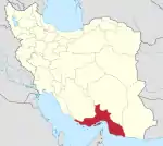 | ||||||||||||||||||||||||
| Counties and cities |
| ||||||||||||||||||||||||
| Sights |
| ||||||||||||||||||||||||
| populated places | |||||||||||||||||||||||||
| See also | |||||||||||||||||||||||||
This article is issued from Wikipedia. The text is licensed under Creative Commons - Attribution - Sharealike. Additional terms may apply for the media files.