 | |
|---|---|
| Route information | |
| Length | 56.2 km (34.9 mi) |
| Major junctions | |
| From | |
| To | |
| Location | |
| Country | Croatia |
| Counties | Zagreb County, Sisak-Moslavina |
| Major cities | Velika Gorica, Glina |
| Highway system | |

Velika Gorica, next to the D31 road
Velika Gorica jug interchange
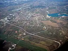
D31 is a state road in central Croatia connecting Velika Gorica and Glina to Croatian motorway network at the A11 motorway Velika Gorica - jug (south) interchange.[1][maps 1] The road also serves as a connection to the A3 motorway via D30 state road. The road is 56.2 km (34.9 mi) long.[2] The road, as well as all other state roads in Croatia, is managed and maintained by Hrvatske ceste, state owned company.[3]
Traffic volume
Traffic is regularly counted and reported by Hrvatske ceste, operator of the road.[4]
| D31 traffic volume | ||||
| Road | Counting site | AADT | ASDT | Notes |
| 2016 Kurilovec | 4,707 | 5,045 | Adjacent to the Ž3111 junction. | |
| 3209 Gornje Taborište | 198 | 229 | Adjacent to the Ž3194 junction. | |
Road junctions and populated areas
| D31 junctions/populated areas | |
| Type | Slip roads/Notes |
To Velika Gorica via Sisačka Street. Both the D31 to the south of the interchange and D30 to the north are double carriage roads. The northern terminus of the road. | |
| To Velika Gorica via Ivana Gorana Kovačića Street. | |
| To Velika Gorica via Stjepana Fabijančića Jape Street. | |
| Velika gorica jug (south) interchange The southern terminus of double carriage road. | |
| To Velika Gorica via Slavka Kolara Street. | |
| Mala Buna | |
| Velika Buna | |
| Kravarsko | |
| Ž3155 to Donji Hruševec. | |
| Gornji Hruševec | |
| Šestak Brdo | |
| Cvetić Brdo | |
The D31 and D36 roads are concurrent to the south of the junction. | |
| Pokupsko | |
The D31 and D36 roads are concurrent to the west of the junction. | |
| Slatina Pokupska Ž3195 to Zaloj and Prekopa (D37). | |
| Ž3194 to Gornja Bučica. | |
| Gornji Viduševac | |
The southern terminus of the road. | |
Maps
- ↑ Overview map of the D31 (Map). OpenStreetMap. Retrieved July 22, 2014.
Footnotes
Sources
- ↑ "Regulation on motorway markings, chainage, interchange/exit/rest area numbers and names". Narodne novine (in Croatian). May 6, 2003.
- ↑ Ministry of Sea, Transport and Infrastructure (Croatia) (July 18, 2014). "Odluka o razvrstavanju javnih cesta" [Decision on categorization of public roads]. Narodne novine (in Croatian) (94/2014). Archived from the original on 2016-03-04.
- ↑ "Public Roads Act". Narodne novine (in Croatian). December 14, 2004.
- ↑ "Traffic counting on the roadways of Croatia in 2013 - digest" (PDF). Hrvatske ceste. May 2014. Archived from the original (PDF) on 2014-07-29. Retrieved 2014-07-22.
This article is issued from Wikipedia. The text is licensed under Creative Commons - Attribution - Sharealike. Additional terms may apply for the media files.