| Chausuyama (Mount Chausu) | |
|---|---|
| 茶臼山 | |
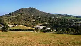 Mount Chause from Chausuyama Plateau | |
| Highest point | |
| Elevation | 1,415.23 m (4,643.1 ft) |
| Geography | |
| Location | Toyone, Aichi / Neba, Nagano, Japan |
| Parent range | Okumikawa |
| Climbing | |
| Easiest route | by car or hiking |
Chausuyama (茶臼山, Mount Chausu) is a mountain located on the border between Aichi and Nagano Prefectures, with its highest point on the Aichi side. With a height of 1,415.2 metres (4,643 ft), it is the tallest peak within Aichi Prefecture. The mountain is within the borders of the Tenryū-Okumikawa Quasi-National Park. During wintertime, the area hosts a popular ski resort.
See also
External links
- Topographical Map Archived 2012-03-26 at the Wayback Machine
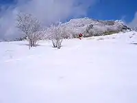
Mount Chausu in winter
Wikimedia Commons has media related to Mount Chausu (Aichi and Nagano).
This article is issued from Wikipedia. The text is licensed under Creative Commons - Attribution - Sharealike. Additional terms may apply for the media files.