Charuymaq County
Persian: شهرستان چاراویماق | |
|---|---|
County | |
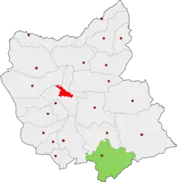 Location of Charuymaq County in East Azerbaijan province | |
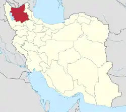 Location of East Azerbaijan province in Iran | |
| Coordinates: 37°05′N 47°10′E / 37.083°N 47.167°E[1] | |
| Country | |
| Province | East Azerbaijan |
| Capital | Qarah Aghaj |
| Districts | Central, Shadian |
| Population (2016) | |
| • Total | 31,071 |
| Time zone | UTC+3:30 (IRST) |
| Website | charoymagh |
| Charuymaq County can be found at GEOnet Names Server, at this link, by opening the Advanced Search box, entering "-3803209" in the "Unique Feature Id" form, and clicking on "Search Database". | |
Charuymaq County (Persian: شهرستان چاراویماق) is in East Azerbaijan province, Iran. Its capital is the city of Qarah Aghaj.[2]
At the 2006 census, the county's population was 33,921 in 6,396 households.[3] The following census in 2011 counted 32,745 people in 8,202 households.[4] At the 2016 census, the county's population was 31,071 in 9,016 households.[5]
Etymology
According to Vladimir Minorsky, the name Chār-oymāq means "the four tribes" (from the Mongolian word aymaq, meaning "tribe").[6]: 69, 76 Until the mid-20th century, the Charuymaq district was known as Oryād or Uryād, after the Oirats, a Mongol tribe.[6]: 69, 72 According to the Ālam-ārā, a tribe known as Uryād historically lived among (but was separate from) the Mukri Kurds.[6]: 68
Administrative divisions
The population history of Charuymaq County's administrative divisions over three consecutive censuses is shown in the following table. The latest census shows two districts, six rural districts, and one city.[5]
| Administrative Divisions | 2006[3] | 2011[4] | 2016[5] |
|---|---|---|---|
| Central District | 21,136 | 20,341 | 19,704 |
| Charuymaq-e Jonubegharbi RD | 4,358 | 3,881 | 3,496 |
| Charuymaq-e Markazi RD | 6,444 | 5,429 | 5,194 |
| Quri Chay-ye Sharqi RD | 2,631 | 2,457 | 2,176 |
| Varqeh RD | 3,546 | 2,922 | 2,736 |
| Qarah Aghaj (city) | 4,157 | 5,652 | 6,102 |
| Shadian District | 12,785 | 12,404 | 11,367 |
| Charuymaq-e Jonubesharqi RD | 5,155 | 4,961 | 4,428 |
| Charuymaq-e Sharqi RD | 7,630 | 7,443 | 6,939 |
| Total | 33,921 | 32,745 | 31,071 |
| RD: Rural District | |||
References
- ↑ OpenStreetMap contributors (3 April 2023). "Charuymaq County" (Map). OpenStreetMap. Retrieved 3 April 2023.
- ↑ Habibi, Hassan (16 June 1379). "Creation of divisional changes and reforms in East Azerbaijan province". Lamtakam (in Persian). Ministry of Interior, Council of Ministers. Archived from the original on 4 December 2023. Retrieved 4 December 2023.
- 1 2 "Census of the Islamic Republic of Iran, 1385 (2006)". AMAR (in Persian). The Statistical Center of Iran. p. 03. Archived from the original (Excel) on 20 September 2011. Retrieved 25 September 2022.
- 1 2 "Census of the Islamic Republic of Iran, 1390 (2011)". Syracuse University (in Persian). The Statistical Center of Iran. p. 03. Archived from the original (Excel) on 16 January 2023. Retrieved 19 December 2022.
- 1 2 3 "Census of the Islamic Republic of Iran, 1395 (2016)". AMAR (in Persian). The Statistical Center of Iran. p. 03. Archived from the original (Excel) on 13 November 2020. Retrieved 19 December 2022.
- 1 2 3 Minorsky, Vladimir (1957). "Mongol Place-Names in Mukri Kurdistan". Bulletin of the School of Oriental and African Studies, University of London. 19 (1): 58–81. doi:10.1017/S0041977X00119202. JSTOR 609632. S2CID 163135242. Retrieved 16 October 2022.
| Capital | |||||||||||||||||||||||||
|---|---|---|---|---|---|---|---|---|---|---|---|---|---|---|---|---|---|---|---|---|---|---|---|---|---|
| Districts |
| ||||||||||||||||||||||||