Central
Buganda | |
|---|---|
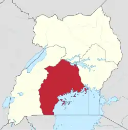 Location of Kampala in Central region, Uganda | |
| Coordinates: 00°19′N 032°35′E / 0.317°N 32.583°E | |
| Country | Uganda |
| Region | Central |
| Regional capital | Kampala |
| Area | |
| • Total | 61,403.2 km2 (23,707.9 sq mi) |
| Elevation | 1,200 m (3,900 ft) |
| Population (2014 census)[2] | |
| • Total | 9,529,227 |
| • Estimate (2011) | 8,465,400 |
| • Density | 160/km2 (400/sq mi) |
| Time zone | EAT |
| HDI (2019) | 0.605[3] medium · 1st |
The Central region is one of the four regions in the country of Uganda.[1] As of Uganda's 2014 census, the region's population was 9,529,227.[2] It is coterminous with the Kingdom of Buganda, one of the ancient African monarchies that are constitutionally recognised in Uganda.
Districts
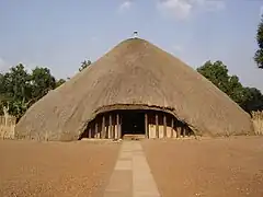
Kampala Kasubi Tombs
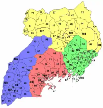
As of 2010, the Central region contains 24 districts:[2]
Central region in red.
| District | Population (Census 1991) | Population (Census 2002) | Population (Census 2014) | Map | Chief town |
|---|---|---|---|---|---|
| Buikwe | 250,511 | 329,858 | 422,771 | 82 | Buikwe |
| Bukomansimbi | 126,549 | 139,556 | 151,413 | 84 | Bukomansimbi |
| Butambala | 74,062 | 86,755 | 100,840 | 86 | Gombe |
| Buvuma | 18,482 | 42,483 | 89,890 | 87 | Kitamilo |
| Gomba | 119,550 | 133,264 | 159,922 | 89 | Kanoni |
| Kalangala | 16,371 | 34,766 | 54,293 | 27 | Kalangala |
| Kalungu | 152,028 | 160,684 | 183,232 | 90 | Kalungu |
| Kampala | 774,241 | 1,189,142 | 1,507,080 | 29 | Kampala |
| Kayunga | 236,177 | 294,613 | 368,062 | 36 | Kayunga |
| Kiboga | 98,153 | 108,897 | 148,218 | 38 | Kiboga |
| Kyankwanzi | 43,454 | 120,575 | 214,693 | 95 | Kyankwanzi |
| Luweero | 255,390 | 341,317 | 456,958 | 48 | Luweero |
| Lwengo | 212,554 | 242,252 | 274,953 | 99 | Lwengo |
| Lyantonde | 53,100 | 66,039 | 93,753 | 100 | Lyantonde |
| Masaka | 203,566 | 228,170 | 297,004 | 51 | Masaka |
| Mityana | 223,527 | 266,108 | 328,964 | 56 | Mityana |
| Mpigi | 157,368 | 187,771 | 250,548 | 59 | Mpigi |
| Mubende | 277,449 | 423,422 | 684,337 | 60 | Mubende |
| Mukono | 319,434 | 423,052 | 596,804 | 61 | Mukono |
| Nakaseke | 93,804 | 137,278 | 197,369 | 63 | Nakaseke |
| Nakasongola | 100,497 | 127,064 | 181,799 | 64 | Nakasongola |
| Rakai | 330,401 | 404,326 | 516,309 | 70 | Rakai |
| Sembabule | 144,039 | 180,045 | 252,597 | 72 | Sembabule |
| Wakiso | 562,887 | 907,988 | 1,997,418 | 76 | Wakiso |
| Total[1][2] | 4,843,594 | 6,575,425 | 9,529,227 | - | Kampala |
References
- 1 2 3 "Uganda: Administrative units (source: Uganda Bureau of Statistics)". GeoHive. Retrieved 18 June 2013.
- 1 2 3 4 "Uganda: Administrative Division". citypopulation.de. Retrieved 5 November 2016.
- ↑ "Sub-national HDI - Area Database - Global Data Lab". hdi.globaldatalab.org. Retrieved 2018-09-13.
External links
This article is issued from Wikipedia. The text is licensed under Creative Commons - Attribution - Sharealike. Additional terms may apply for the media files.